You are here: Home > Network List > TA - USArray Transportable Network (new EarthScope stations) Stations List
> Station SFIN Lafayette, IN, USA > Earthquake Result Viewer
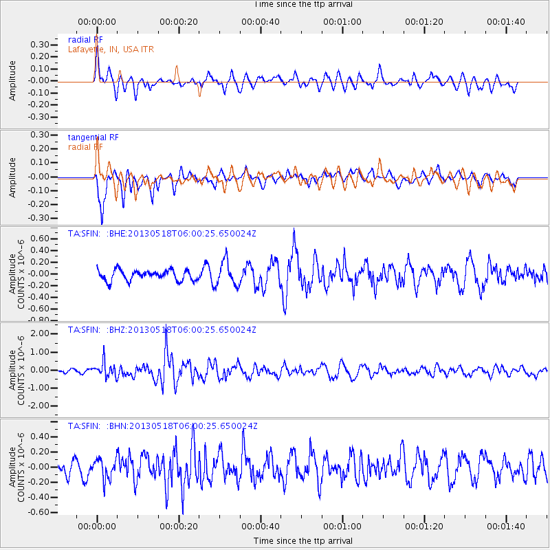
SFIN Lafayette, IN, USA - Earthquake Result Viewer
*The percent match for this event was below the threshold and hence no stack was calculated.
| Earthquake location: |
Near East Coast Of Honshu, Japan |
| Earthquake latitude/longitude: |
37.7/141.5 |
| Earthquake time(UTC): |
2013/05/18 (138) 05:47:59 GMT |
| Earthquake Depth: |
39 km |
| Earthquake Magnitude: |
6.0 MW, 5.5 MS, 6.0 MW, 6.1 MB |
| Earthquake Catalog/Contributor: |
NEIC PDE/NEIC PDE-W |
|
| Network: |
TA USArray Transportable Network (new EarthScope stations) |
| Station: |
SFIN Lafayette, IN, USA |
| Lat/Lon: |
40.38 N/87.10 W |
| Elevation: |
165 m |
|
| Distance: |
90.4 deg |
| Az: |
34.943 deg |
| Baz: |
323.53 deg |
| Ray Param: |
$rayparam |
*The percent match for this event was below the threshold and hence was not used in the summary stack. |
|
| Radial Match: |
56.881065 % |
| Radial Bump: |
400 |
| Transverse Match: |
78.398834 % |
| Transverse Bump: |
397 |
| SOD ConfigId: |
512894 |
| Insert Time: |
2013-09-14 07:10:32.728 +0000 |
| GWidth: |
2.5 |
| Max Bumps: |
400 |
| Tol: |
0.001 |
|
Signal To Noise
| Channel | StoN | STA | LTA |
| TA:SFIN: :BHZ:20130518T06:00:25.650024Z | 3.9617267 | 4.1387662E-7 | 1.0446875E-7 |
| TA:SFIN: :BHN:20130518T06:00:25.650024Z | 1.2644478 | 1.3644994E-7 | 1.0791267E-7 |
| TA:SFIN: :BHE:20130518T06:00:25.650024Z | 2.302108 | 2.0795441E-7 | 9.0332165E-8 |
| Arrivals |
| Ps | |
| PpPs | |
| PsPs/PpSs | |


