You are here: Home > Network List > US - United States National Seismic Network Stations List
> Station DGMT Dagmar, Montana, USA > Earthquake Result Viewer
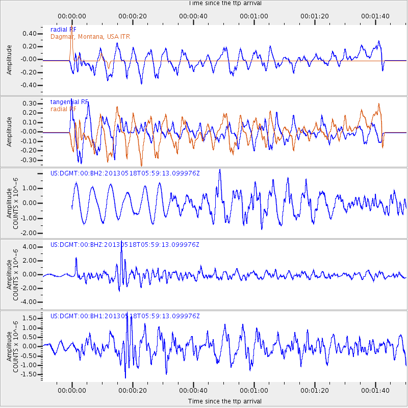
DGMT Dagmar, Montana, USA - Earthquake Result Viewer
*The percent match for this event was below the threshold and hence no stack was calculated.
| Earthquake location: |
Near East Coast Of Honshu, Japan |
| Earthquake latitude/longitude: |
37.7/141.5 |
| Earthquake time(UTC): |
2013/05/18 (138) 05:47:59 GMT |
| Earthquake Depth: |
39 km |
| Earthquake Magnitude: |
6.0 MW, 5.5 MS, 6.0 MW, 6.1 MB |
| Earthquake Catalog/Contributor: |
NEIC PDE/NEIC PDE-W |
|
| Network: |
US United States National Seismic Network |
| Station: |
DGMT Dagmar, Montana, USA |
| Lat/Lon: |
48.47 N/104.20 W |
| Elevation: |
0.0 m |
|
| Distance: |
76.3 deg |
| Az: |
38.627 deg |
| Baz: |
311.957 deg |
| Ray Param: |
$rayparam |
*The percent match for this event was below the threshold and hence was not used in the summary stack. |
|
| Radial Match: |
37.157814 % |
| Radial Bump: |
378 |
| Transverse Match: |
52.932304 % |
| Transverse Bump: |
371 |
| SOD ConfigId: |
512894 |
| Insert Time: |
2013-09-14 07:14:32.164 +0000 |
| GWidth: |
2.5 |
| Max Bumps: |
400 |
| Tol: |
0.001 |
|
Signal To Noise
| Channel | StoN | STA | LTA |
| US:DGMT:00:BHZ:20130518T05:59:13.099976Z | 6.558188 | 7.2492963E-7 | 1.10538096E-7 |
| US:DGMT:00:BH1:20130518T05:59:13.099976Z | 0.652908 | 2.5139303E-7 | 3.850359E-7 |
| US:DGMT:00:BH2:20130518T05:59:13.099976Z | 0.7695282 | 6.0978044E-7 | 7.924082E-7 |
| Arrivals |
| Ps | |
| PpPs | |
| PsPs/PpSs | |


