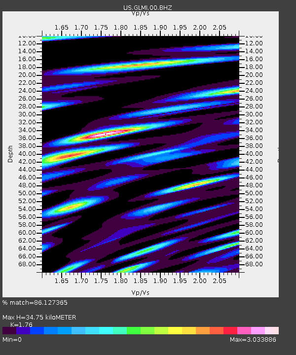
GLMI Grayling, Michigan, USA - Earthquake Result Viewer

Earthquake location: Near East Coast Of Honshu, Japan
Earthquake latitude/longitude: 37.7/141.5
Earthquake time(UTC): 2013/05/18 (138) 05:47:59 GMT
Earthquake Depth: 39 km
Earthquake Magnitude: 6.0 MW, 5.5 MS, 6.0 MW, 6.1 MB
Earthquake Catalog/Contributor: NEIC PDE/NEIC PDE-W
Network: US United States National Seismic Network
Station: GLMI Grayling, Michigan, USA
Lat/Lon: 44.82 N/84.62 W
Elevation: 387 m
Distance: 87.9 deg
Az: 30.865 deg
Baz: 325.143 deg
Ray Param: 0.04294155
Estimated Moho Depth: 34.75 km
Estimated Crust Vp/Vs: 1.76
Assumed Crust Vp: 6.483 km/s
Estimated Crust Vs: 3.683 km/s
Estimated Crust Poisson's Ratio: 0.26
Radial Match: 86.127365 %
Radial Bump: 360
Transverse Match: 82.85945 %
Transverse Bump: 400
SOD ConfigId: 512894
Insert Time: 2013-09-14 07:14:52.472 +0000
GWidth: 2.5
Max Bumps: 400
Tol: 0.001

Signal To Noise

ChannelStoNSTALTA
US:GLMI:00:BHZ:20130518T06:00:13.750Z4.56712871.0770266E-62.3582137E-7
US:GLMI:00:BH1:20130518T06:00:13.750Z1.92043456.910149E-73.598222E-7
US:GLMI:00:BH2:20130518T06:00:13.750Z2.6083145.367331E-72.0577781E-7
Arrivals
Ps4.2 SECOND
PpPs14 SECOND
PsPs/PpSs19 SECOND