You are here: Home > Network List > US - United States National Seismic Network Stations List
> Station MSO Missoula, Montana, USA > Earthquake Result Viewer
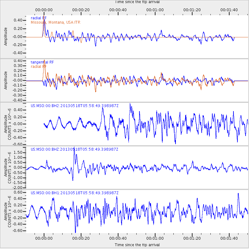
MSO Missoula, Montana, USA - Earthquake Result Viewer
*The percent match for this event was below the threshold and hence no stack was calculated.
| Earthquake location: |
Near East Coast Of Honshu, Japan |
| Earthquake latitude/longitude: |
37.7/141.5 |
| Earthquake time(UTC): |
2013/05/18 (138) 05:47:59 GMT |
| Earthquake Depth: |
39 km |
| Earthquake Magnitude: |
6.0 MW, 5.5 MS, 6.0 MW, 6.1 MB |
| Earthquake Catalog/Contributor: |
NEIC PDE/NEIC PDE-W |
|
| Network: |
US United States National Seismic Network |
| Station: |
MSO Missoula, Montana, USA |
| Lat/Lon: |
46.83 N/113.94 W |
| Elevation: |
1264 m |
|
| Distance: |
72.2 deg |
| Az: |
44.264 deg |
| Baz: |
306.304 deg |
| Ray Param: |
$rayparam |
*The percent match for this event was below the threshold and hence was not used in the summary stack. |
|
| Radial Match: |
69.682236 % |
| Radial Bump: |
400 |
| Transverse Match: |
67.455505 % |
| Transverse Bump: |
400 |
| SOD ConfigId: |
512894 |
| Insert Time: |
2013-09-14 07:15:34.045 +0000 |
| GWidth: |
2.5 |
| Max Bumps: |
400 |
| Tol: |
0.001 |
|
Signal To Noise
| Channel | StoN | STA | LTA |
| US:MSO:00:BHZ:20130518T05:58:49.398987Z | 2.8477042 | 2.3624928E-7 | 8.2961314E-8 |
| US:MSO:00:BH1:20130518T05:58:49.398987Z | 2.0559857 | 2.1500735E-7 | 1.0457629E-7 |
| US:MSO:00:BH2:20130518T05:58:49.398987Z | 2.718972 | 2.5008836E-7 | 9.197902E-8 |
| Arrivals |
| Ps | |
| PpPs | |
| PsPs/PpSs | |


