You are here: Home > Network List > TA - USArray Transportable Network (new EarthScope stations) Stations List
> Station P60A Greenville, DE, USA > Earthquake Result Viewer
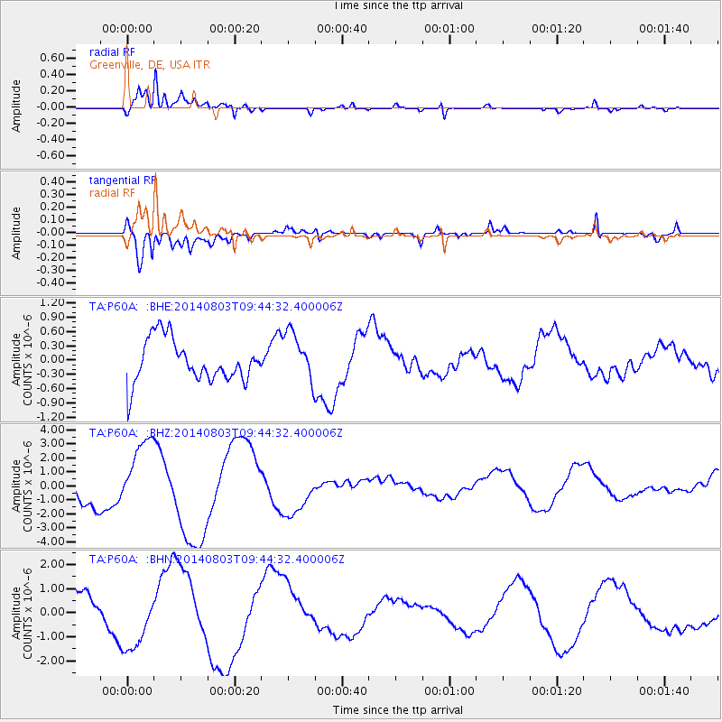
P60A Greenville, DE, USA - Earthquake Result Viewer
*The percent match for this event was below the threshold and hence no stack was calculated.
| Earthquake location: |
Near West Coast Of Colombia |
| Earthquake latitude/longitude: |
3.6/-77.7 |
| Earthquake time(UTC): |
2014/08/03 (215) 09:38:06 GMT |
| Earthquake Depth: |
62 km |
| Earthquake Magnitude: |
5.2 mb, 5.0 Mwr |
| Earthquake Catalog/Contributor: |
ISC/ISC |
|
| Network: |
TA USArray Transportable Network (new EarthScope stations) |
| Station: |
P60A Greenville, DE, USA |
| Lat/Lon: |
39.81 N/75.64 W |
| Elevation: |
105 m |
|
| Distance: |
36.1 deg |
| Az: |
2.691 deg |
| Baz: |
183.487 deg |
| Ray Param: |
$rayparam |
*The percent match for this event was below the threshold and hence was not used in the summary stack. |
|
| Radial Match: |
94.348366 % |
| Radial Bump: |
400 |
| Transverse Match: |
73.623604 % |
| Transverse Bump: |
400 |
| SOD ConfigId: |
3390531 |
| Insert Time: |
2019-04-13 04:43:44.221 +0000 |
| GWidth: |
2.5 |
| Max Bumps: |
400 |
| Tol: |
0.001 |
|
Signal To Noise
| Channel | StoN | STA | LTA |
| TA:P60A: :BHZ:20140803T09:44:32.400006Z | 3.3982153 | 2.5983336E-6 | 7.646171E-7 |
| TA:P60A: :BHN:20140803T09:44:32.400006Z | 2.4957206 | 1.3200677E-6 | 5.2893245E-7 |
| TA:P60A: :BHE:20140803T09:44:32.400006Z | 1.1732126 | 5.218189E-7 | 4.4477775E-7 |
| Arrivals |
| Ps | |
| PpPs | |
| PsPs/PpSs | |


