You are here: Home > Network List > TA - USArray Transportable Network (new EarthScope stations) Stations List
> Station Q53A Leroy, WV, USA > Earthquake Result Viewer
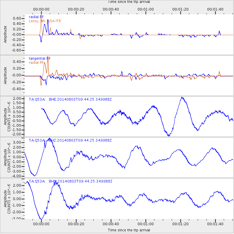
Q53A Leroy, WV, USA - Earthquake Result Viewer
*The percent match for this event was below the threshold and hence no stack was calculated.
| Earthquake location: |
Near West Coast Of Colombia |
| Earthquake latitude/longitude: |
3.6/-77.7 |
| Earthquake time(UTC): |
2014/08/03 (215) 09:38:06 GMT |
| Earthquake Depth: |
62 km |
| Earthquake Magnitude: |
5.2 mb, 5.0 Mwr |
| Earthquake Catalog/Contributor: |
ISC/ISC |
|
| Network: |
TA USArray Transportable Network (new EarthScope stations) |
| Station: |
Q53A Leroy, WV, USA |
| Lat/Lon: |
38.86 N/81.53 W |
| Elevation: |
310 m |
|
| Distance: |
35.3 deg |
| Az: |
354.819 deg |
| Baz: |
173.371 deg |
| Ray Param: |
$rayparam |
*The percent match for this event was below the threshold and hence was not used in the summary stack. |
|
| Radial Match: |
93.527596 % |
| Radial Bump: |
400 |
| Transverse Match: |
64.18933 % |
| Transverse Bump: |
400 |
| SOD ConfigId: |
3390531 |
| Insert Time: |
2019-04-13 04:43:45.155 +0000 |
| GWidth: |
2.5 |
| Max Bumps: |
400 |
| Tol: |
0.001 |
|
Signal To Noise
| Channel | StoN | STA | LTA |
| TA:Q53A: :BHZ:20140803T09:44:25.349988Z | 1.6370372 | 2.4867645E-6 | 1.5190641E-6 |
| TA:Q53A: :BHN:20140803T09:44:25.349988Z | 1.8406372 | 2.415378E-6 | 1.312251E-6 |
| TA:Q53A: :BHE:20140803T09:44:25.349988Z | 0.9146796 | 5.1223407E-7 | 5.6001477E-7 |
| Arrivals |
| Ps | |
| PpPs | |
| PsPs/PpSs | |


