You are here: Home > Network List > UW - Pacific Northwest Regional Seismic Network Stations List
> Station UMAT Pilot Rock, OR, USA > Earthquake Result Viewer
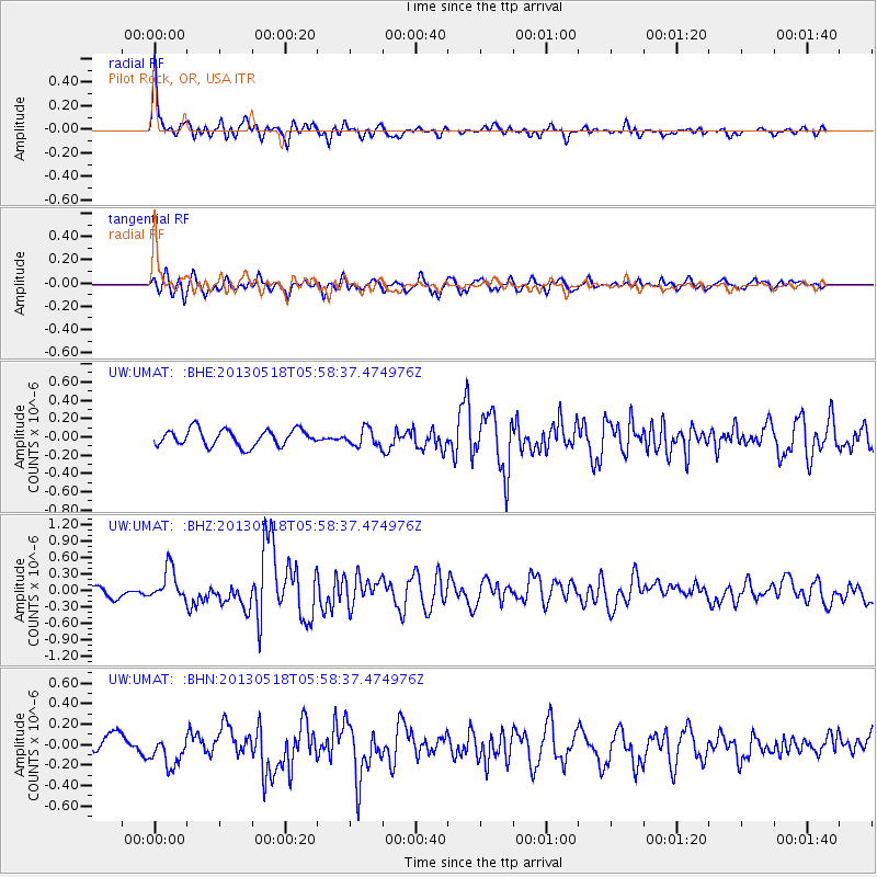
UMAT Pilot Rock, OR, USA - Earthquake Result Viewer
*The percent match for this event was below the threshold and hence no stack was calculated.
| Earthquake location: |
Near East Coast Of Honshu, Japan |
| Earthquake latitude/longitude: |
37.7/141.5 |
| Earthquake time(UTC): |
2013/05/18 (138) 05:47:59 GMT |
| Earthquake Depth: |
39 km |
| Earthquake Magnitude: |
6.0 MW, 5.5 MS, 6.0 MW, 6.1 MB |
| Earthquake Catalog/Contributor: |
NEIC PDE/NEIC PDE-W |
|
| Network: |
UW Pacific Northwest Regional Seismic Network |
| Station: |
UMAT Pilot Rock, OR, USA |
| Lat/Lon: |
45.29 N/118.96 W |
| Elevation: |
1318 m |
|
| Distance: |
70.2 deg |
| Az: |
47.714 deg |
| Baz: |
303.813 deg |
| Ray Param: |
$rayparam |
*The percent match for this event was below the threshold and hence was not used in the summary stack. |
|
| Radial Match: |
77.936584 % |
| Radial Bump: |
400 |
| Transverse Match: |
72.658585 % |
| Transverse Bump: |
400 |
| SOD ConfigId: |
512894 |
| Insert Time: |
2013-09-14 07:19:12.350 +0000 |
| GWidth: |
2.5 |
| Max Bumps: |
400 |
| Tol: |
0.001 |
|
Signal To Noise
| Channel | StoN | STA | LTA |
| UW:UMAT: :BHZ:20130518T05:58:37.474976Z | 3.1420193 | 2.8978155E-7 | 9.222781E-8 |
| UW:UMAT: :BHN:20130518T05:58:37.474976Z | 1.6437407 | 1.4822544E-7 | 9.017569E-8 |
| UW:UMAT: :BHE:20130518T05:58:37.474976Z | 1.050157 | 9.406342E-8 | 8.957082E-8 |
| Arrivals |
| Ps | |
| PpPs | |
| PsPs/PpSs | |


