You are here: Home > Network List > UU - University of Utah Regional Network Stations List
> Station CCUT Cedar City, UT, USA > Earthquake Result Viewer
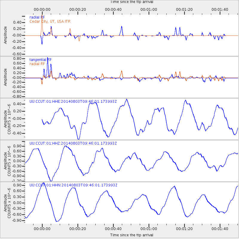
CCUT Cedar City, UT, USA - Earthquake Result Viewer
*The percent match for this event was below the threshold and hence no stack was calculated.
| Earthquake location: |
Near West Coast Of Colombia |
| Earthquake latitude/longitude: |
3.6/-77.7 |
| Earthquake time(UTC): |
2014/08/03 (215) 09:38:06 GMT |
| Earthquake Depth: |
62 km |
| Earthquake Magnitude: |
5.2 mb, 5.0 Mwr |
| Earthquake Catalog/Contributor: |
ISC/ISC |
|
| Network: |
UU University of Utah Regional Network |
| Station: |
CCUT Cedar City, UT, USA |
| Lat/Lon: |
37.55 N/113.36 W |
| Elevation: |
2127 m |
|
| Distance: |
47.0 deg |
| Az: |
320.67 deg |
| Baz: |
127.261 deg |
| Ray Param: |
$rayparam |
*The percent match for this event was below the threshold and hence was not used in the summary stack. |
|
| Radial Match: |
66.52774 % |
| Radial Bump: |
400 |
| Transverse Match: |
90.68672 % |
| Transverse Bump: |
358 |
| SOD ConfigId: |
3390531 |
| Insert Time: |
2019-04-13 04:44:30.331 +0000 |
| GWidth: |
2.5 |
| Max Bumps: |
400 |
| Tol: |
0.001 |
|
Signal To Noise
| Channel | StoN | STA | LTA |
| UU:CCUT:01:HHZ:20140803T09:46:01.173993Z | 2.5162797 | 5.9774186E-7 | 2.3754987E-7 |
| UU:CCUT:01:HHN:20140803T09:46:01.173993Z | 2.86972 | 8.510564E-7 | 2.9656428E-7 |
| UU:CCUT:01:HHE:20140803T09:46:01.173993Z | 1.6151328 | 3.4316062E-7 | 2.1246589E-7 |
| Arrivals |
| Ps | |
| PpPs | |
| PsPs/PpSs | |


