You are here: Home > Network List > TA - USArray Transportable Network (new EarthScope stations) Stations List
> Station U52A Thorn Hill, TN, USA > Earthquake Result Viewer
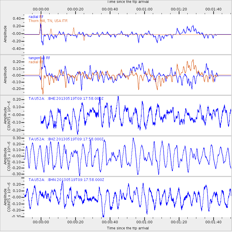
U52A Thorn Hill, TN, USA - Earthquake Result Viewer
*The percent match for this event was below the threshold and hence no stack was calculated.
| Earthquake location: |
Northern Algeria |
| Earthquake latitude/longitude: |
36.7/5.3 |
| Earthquake time(UTC): |
2013/05/19 (139) 09:07:26 GMT |
| Earthquake Depth: |
6.7 km |
| Earthquake Magnitude: |
5.5 ML |
| Earthquake Catalog/Contributor: |
NEIC PDE/NEIC PDE-W |
|
| Network: |
TA USArray Transportable Network (new EarthScope stations) |
| Station: |
U52A Thorn Hill, TN, USA |
| Lat/Lon: |
36.39 N/83.37 W |
| Elevation: |
510 m |
|
| Distance: |
68.5 deg |
| Az: |
299.869 deg |
| Baz: |
59.737 deg |
| Ray Param: |
$rayparam |
*The percent match for this event was below the threshold and hence was not used in the summary stack. |
|
| Radial Match: |
44.197407 % |
| Radial Bump: |
400 |
| Transverse Match: |
39.588493 % |
| Transverse Bump: |
400 |
| SOD ConfigId: |
512894 |
| Insert Time: |
2013-09-14 08:17:43.624 +0000 |
| GWidth: |
2.5 |
| Max Bumps: |
400 |
| Tol: |
0.001 |
|
Signal To Noise
| Channel | StoN | STA | LTA |
| TA:U52A: :BHZ:20130519T09:17:58.000Z | 1.3229148 | 1.4124674E-7 | 1.0676934E-7 |
| TA:U52A: :BHN:20130519T09:17:58.000Z | 1.3306825 | 1.233883E-7 | 9.272558E-8 |
| TA:U52A: :BHE:20130519T09:17:58.000Z | 1.4769626 | 1.3191672E-7 | 8.9316224E-8 |
| Arrivals |
| Ps | |
| PpPs | |
| PsPs/PpSs | |


