You are here: Home > Network List > TA - USArray Transportable Network (new EarthScope stations) Stations List
> Station WHTX Lake Whitney, Meridian, TX, USA > Earthquake Result Viewer
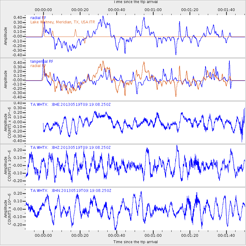
WHTX Lake Whitney, Meridian, TX, USA - Earthquake Result Viewer
*The percent match for this event was below the threshold and hence no stack was calculated.
| Earthquake location: |
Northern Algeria |
| Earthquake latitude/longitude: |
36.7/5.3 |
| Earthquake time(UTC): |
2013/05/19 (139) 09:07:26 GMT |
| Earthquake Depth: |
6.7 km |
| Earthquake Magnitude: |
5.5 ML |
| Earthquake Catalog/Contributor: |
NEIC PDE/NEIC PDE-W |
|
| Network: |
TA USArray Transportable Network (new EarthScope stations) |
| Station: |
WHTX Lake Whitney, Meridian, TX, USA |
| Lat/Lon: |
31.99 N/97.46 W |
| Elevation: |
190 m |
|
| Distance: |
80.6 deg |
| Az: |
302.842 deg |
| Baz: |
52.62 deg |
| Ray Param: |
$rayparam |
*The percent match for this event was below the threshold and hence was not used in the summary stack. |
|
| Radial Match: |
58.326927 % |
| Radial Bump: |
400 |
| Transverse Match: |
42.766373 % |
| Transverse Bump: |
400 |
| SOD ConfigId: |
512894 |
| Insert Time: |
2013-09-14 08:19:00.970 +0000 |
| GWidth: |
2.5 |
| Max Bumps: |
400 |
| Tol: |
0.001 |
|
Signal To Noise
| Channel | StoN | STA | LTA |
| TA:WHTX: :BHZ:20130519T09:19:08.250Z | 0.97704977 | 9.7732354E-8 | 1.0002802E-7 |
| TA:WHTX: :BHN:20130519T09:19:08.250Z | 0.9466989 | 1.0873486E-7 | 1.1485685E-7 |
| TA:WHTX: :BHE:20130519T09:19:08.250Z | 1.9325137 | 2.0917373E-7 | 1.082392E-7 |
| Arrivals |
| Ps | |
| PpPs | |
| PsPs/PpSs | |


