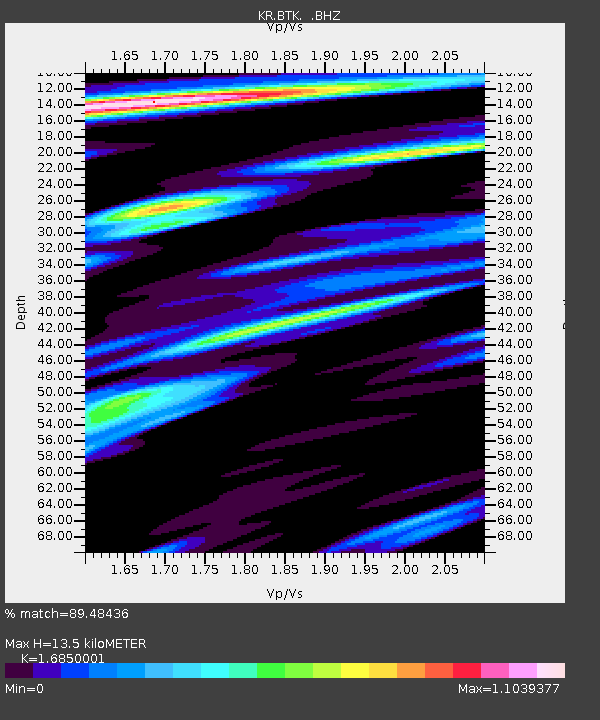
BTK Batken, Kyrgyzstan - Earthquake Result Viewer

Earthquake location: Off East Coast Of Kamchatka
Earthquake latitude/longitude: 52.3/160.1
Earthquake time(UTC): 2013/05/19 (139) 18:44:10 GMT
Earthquake Depth: 18 km
Earthquake Magnitude: 6.1 MW, 5.8 MS, 5.9 MB, 5.9 MW
Earthquake Catalog/Contributor: NEIC PDE/NEIC PDE-W
Network: KR Kyrgyz Digital Network
Station: BTK Batken, Kyrgyzstan
Lat/Lon: 40.06 N/70.82 E
Elevation: 980 m
Distance: 59.2 deg
Az: 296.662 deg
Baz: 45.595 deg
Ray Param: 0.062344026
Estimated Moho Depth: 13.5 km
Estimated Crust Vp/Vs: 1.69
Assumed Crust Vp: 6.236 km/s
Estimated Crust Vs: 3.701 km/s
Estimated Crust Poisson's Ratio: 0.23
Radial Match: 89.48436 %
Radial Bump: 400
Transverse Match: 88.4836 %
Transverse Bump: 400
SOD ConfigId: 512894
Insert Time: 2013-09-14 08:45:11.580 +0000
GWidth: 2.5
Max Bumps: 400
Tol: 0.001

Signal To Noise

ChannelStoNSTALTA
KR:BTK: :BHZ:20130519T18:53:39.624988Z22.958031.3853808E-66.034406E-8
KR:BTK: :BHN:20130519T18:53:39.624988Z8.5135964.1271147E-74.8476753E-8
KR:BTK: :BHE:20130519T18:53:39.624988Z10.0306284.2096946E-74.1968406E-8
Arrivals
Ps1.6 SECOND
PpPs5.5 SECOND
PsPs/PpSs7.1 SECOND