You are here: Home > Network List > TA - USArray Transportable Network (new EarthScope stations) Stations List
> Station 351A Pinckard, AL, USA > Earthquake Result Viewer
351A Pinckard, AL, USA - Earthquake Result Viewer
| Earthquake location: |
Off East Coast Of Kamchatka |
| Earthquake latitude/longitude: |
52.3/160.1 |
| Earthquake time(UTC): |
2013/05/19 (139) 18:44:10 GMT |
| Earthquake Depth: |
18 km |
| Earthquake Magnitude: |
6.1 MW, 5.8 MS, 5.9 MB, 5.9 MW |
| Earthquake Catalog/Contributor: |
NEIC PDE/NEIC PDE-W |
|
| Network: |
TA USArray Transportable Network (new EarthScope stations) |
| Station: |
351A Pinckard, AL, USA |
| Lat/Lon: |
31.28 N/85.60 W |
| Elevation: |
48 m |
|
| Distance: |
79.0 deg |
| Az: |
52.644 deg |
| Baz: |
325.278 deg |
| Ray Param: |
0.04927342 |
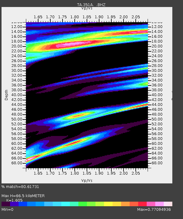
| Estimated Moho Depth: |
66.5 km |
| Estimated Crust Vp/Vs: |
1.61 |
| Assumed Crust Vp: |
6.347 km/s |
| Estimated Crust Vs: |
3.955 km/s |
| Estimated Crust Poisson's Ratio: |
0.18 |
|
| Radial Match: |
80.61731 % |
| Radial Bump: |
400 |
| Transverse Match: |
74.565674 % |
| Transverse Bump: |
400 |
| SOD ConfigId: |
512894 |
| Insert Time: |
2013-09-14 08:59:02.780 +0000 |
| GWidth: |
2.5 |
| Max Bumps: |
400 |
| Tol: |
0.001 |
|

Signal To Noise
| Channel | StoN | STA | LTA |
| TA:351A: :BHZ:20130519T18:55:42.075Z | 4.5781136 | 4.6595923E-7 | 1.0177975E-7 |
| TA:351A: :BHN:20130519T18:55:42.075Z | 1.2167768 | 2.4954525E-7 | 2.0508712E-7 |
| TA:351A: :BHE:20130519T18:55:42.075Z | 0.5928762 | 1.4465748E-7 | 2.4399273E-7 |
| Arrivals |
| Ps | 6.5 SECOND |
| PpPs | 26 SECOND |
| PsPs/PpSs | 33 SECOND |


