You are here: Home > Network List > TA - USArray Transportable Network (new EarthScope stations) Stations List
> Station 452A Marianna, FL, USA > Earthquake Result Viewer
452A Marianna, FL, USA - Earthquake Result Viewer
| Earthquake location: |
Off East Coast Of Kamchatka |
| Earthquake latitude/longitude: |
52.3/160.1 |
| Earthquake time(UTC): |
2013/05/19 (139) 18:44:10 GMT |
| Earthquake Depth: |
18 km |
| Earthquake Magnitude: |
6.1 MW, 5.8 MS, 5.9 MB, 5.9 MW |
| Earthquake Catalog/Contributor: |
NEIC PDE/NEIC PDE-W |
|
| Network: |
TA USArray Transportable Network (new EarthScope stations) |
| Station: |
452A Marianna, FL, USA |
| Lat/Lon: |
30.85 N/85.18 W |
| Elevation: |
35 m |
|
| Distance: |
79.5 deg |
| Az: |
52.587 deg |
| Baz: |
325.484 deg |
| Ray Param: |
0.048893813 |
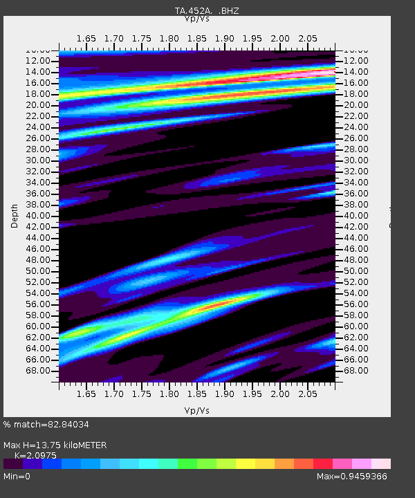
| Estimated Moho Depth: |
13.75 km |
| Estimated Crust Vp/Vs: |
2.10 |
| Assumed Crust Vp: |
6.347 km/s |
| Estimated Crust Vs: |
3.026 km/s |
| Estimated Crust Poisson's Ratio: |
0.35 |
|
| Radial Match: |
82.84034 % |
| Radial Bump: |
400 |
| Transverse Match: |
70.948204 % |
| Transverse Bump: |
400 |
| SOD ConfigId: |
512894 |
| Insert Time: |
2013-09-14 08:59:27.474 +0000 |
| GWidth: |
2.5 |
| Max Bumps: |
400 |
| Tol: |
0.001 |
|
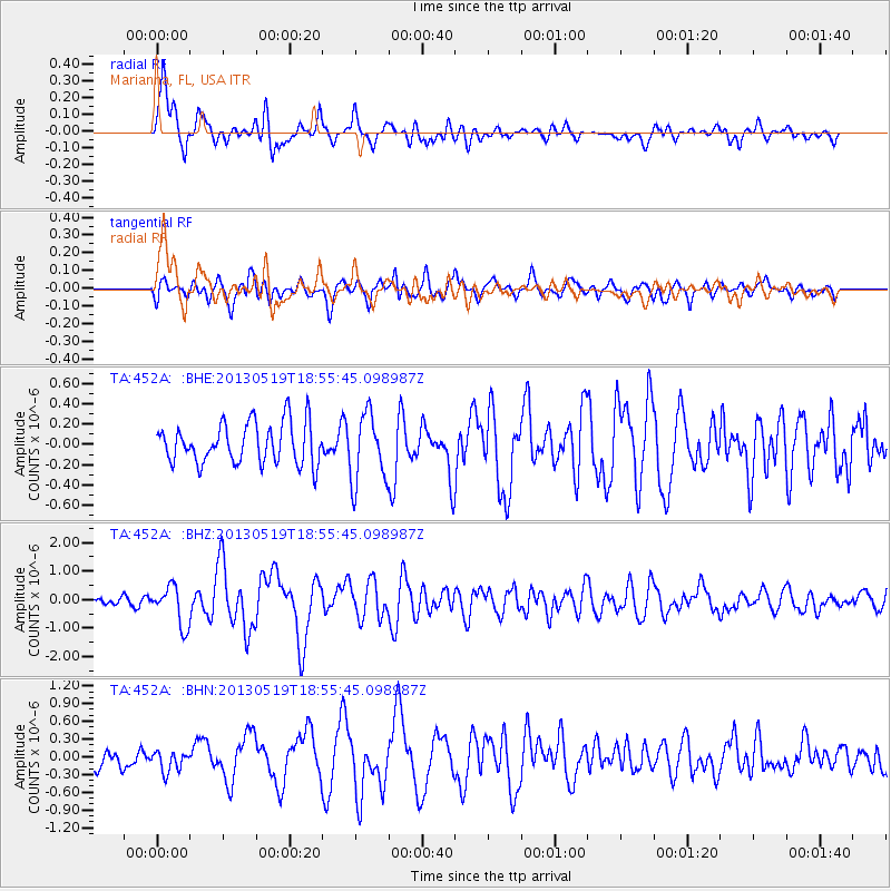
Signal To Noise
| Channel | StoN | STA | LTA |
| TA:452A: :BHZ:20130519T18:55:45.098987Z | 5.2236714 | 6.9375085E-7 | 1.3280905E-7 |
| TA:452A: :BHN:20130519T18:55:45.098987Z | 1.0100005 | 1.8947831E-7 | 1.876022E-7 |
| TA:452A: :BHE:20130519T18:55:45.098987Z | 1.6814274 | 3.3627884E-7 | 1.9999607E-7 |
| Arrivals |
| Ps | 2.4 SECOND |
| PpPs | 6.6 SECOND |
| PsPs/PpSs | 9.0 SECOND |


