You are here: Home > Network List > TA - USArray Transportable Network (new EarthScope stations) Stations List
> Station 556A Lake Butler, FL, USA > Earthquake Result Viewer
556A Lake Butler, FL, USA - Earthquake Result Viewer
| Earthquake location: |
Off East Coast Of Kamchatka |
| Earthquake latitude/longitude: |
52.3/160.1 |
| Earthquake time(UTC): |
2013/05/19 (139) 18:44:10 GMT |
| Earthquake Depth: |
18 km |
| Earthquake Magnitude: |
6.1 MW, 5.8 MS, 5.9 MB, 5.9 MW |
| Earthquake Catalog/Contributor: |
NEIC PDE/NEIC PDE-W |
|
| Network: |
TA USArray Transportable Network (new EarthScope stations) |
| Station: |
556A Lake Butler, FL, USA |
| Lat/Lon: |
30.00 N/82.41 W |
| Elevation: |
45 m |
|
| Distance: |
81.6 deg |
| Az: |
51.048 deg |
| Baz: |
326.63 deg |
| Ray Param: |
0.04749002 |
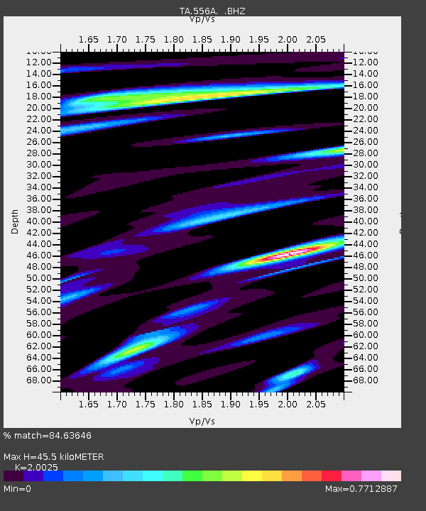
| Estimated Moho Depth: |
45.5 km |
| Estimated Crust Vp/Vs: |
2.00 |
| Assumed Crust Vp: |
6.565 km/s |
| Estimated Crust Vs: |
3.278 km/s |
| Estimated Crust Poisson's Ratio: |
0.33 |
|
| Radial Match: |
84.63646 % |
| Radial Bump: |
400 |
| Transverse Match: |
61.577812 % |
| Transverse Bump: |
400 |
| SOD ConfigId: |
512894 |
| Insert Time: |
2013-09-14 08:59:56.832 +0000 |
| GWidth: |
2.5 |
| Max Bumps: |
400 |
| Tol: |
0.001 |
|
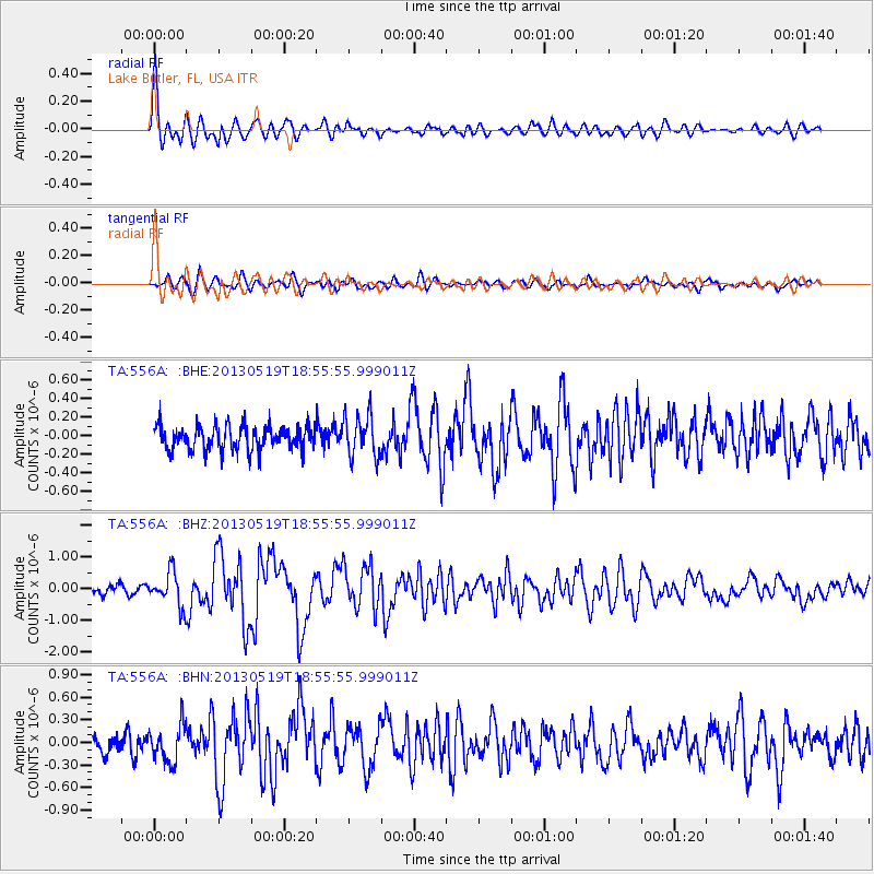
Signal To Noise
| Channel | StoN | STA | LTA |
| TA:556A: :BHZ:20130519T18:55:55.999011Z | 3.7879164 | 5.3770356E-7 | 1.4195234E-7 |
| TA:556A: :BHN:20130519T18:55:55.999011Z | 1.9099685 | 2.4926533E-7 | 1.3050756E-7 |
| TA:556A: :BHE:20130519T18:55:55.999011Z | 1.7499248 | 2.257976E-7 | 1.2903274E-7 |
| Arrivals |
| Ps | 7.1 SECOND |
| PpPs | 20 SECOND |
| PsPs/PpSs | 27 SECOND |


