You are here: Home > Network List > TA - USArray Transportable Network (new EarthScope stations) Stations List
> Station E39A Mellen, WI, USA > Earthquake Result Viewer
E39A Mellen, WI, USA - Earthquake Result Viewer

| Earthquake location: |
Off East Coast Of Kamchatka |
| Earthquake latitude/longitude: |
52.3/160.1 |
| Earthquake time(UTC): |
2013/05/19 (139) 18:44:10 GMT |
| Earthquake Depth: |
18 km |
| Earthquake Magnitude: |
6.1 MW, 5.8 MS, 5.9 MB, 5.9 MW |
| Earthquake Catalog/Contributor: |
NEIC PDE/NEIC PDE-W |
|
| Network: |
TA USArray Transportable Network (new EarthScope stations) |
| Station: |
E39A Mellen, WI, USA |
| Lat/Lon: |
46.38 N/90.56 W |
| Elevation: |
426 m |
|
| Distance: |
64.6 deg |
| Az: |
46.299 deg |
| Baz: |
320.157 deg |
| Ray Param: |
0.05879831 |
| Estimated Moho Depth: |
37.0 km |
| Estimated Crust Vp/Vs: |
2.00 |
| Assumed Crust Vp: |
6.467 km/s |
| Estimated Crust Vs: |
3.229 km/s |
| Estimated Crust Poisson's Ratio: |
0.33 |
|
| Radial Match: |
84.601 % |
| Radial Bump: |
400 |
| Transverse Match: |
73.44741 % |
| Transverse Bump: |
400 |
| SOD ConfigId: |
512894 |
| Insert Time: |
2013-09-14 09:01:16.276 +0000 |
| GWidth: |
2.5 |
| Max Bumps: |
400 |
| Tol: |
0.001 |
|
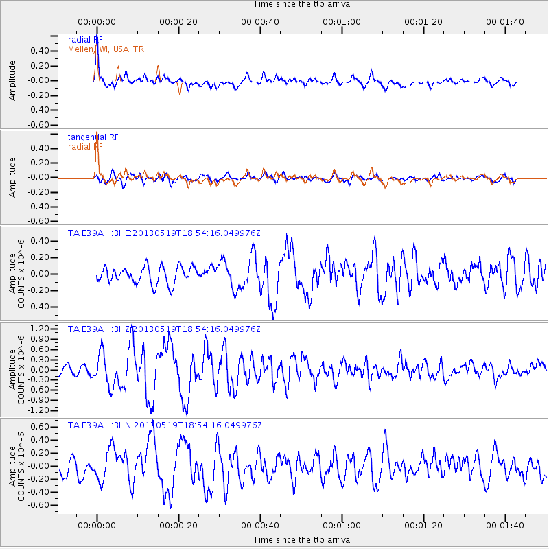
Signal To Noise
| Channel | StoN | STA | LTA |
| TA:E39A: :BHZ:20130519T18:54:16.049976Z | 5.46201 | 4.824823E-7 | 8.83342E-8 |
| TA:E39A: :BHN:20130519T18:54:16.049976Z | 1.8912319 | 2.5131664E-7 | 1.3288515E-7 |
| TA:E39A: :BHE:20130519T18:54:16.049976Z | 1.5942782 | 1.630264E-7 | 1.0225718E-7 |
| Arrivals |
| Ps | 6.0 SECOND |
| PpPs | 17 SECOND |
| PsPs/PpSs | 22 SECOND |


