You are here: Home > Network List > TA - USArray Transportable Network (new EarthScope stations) Stations List
> Station Q53A Leroy, WV, USA > Earthquake Result Viewer
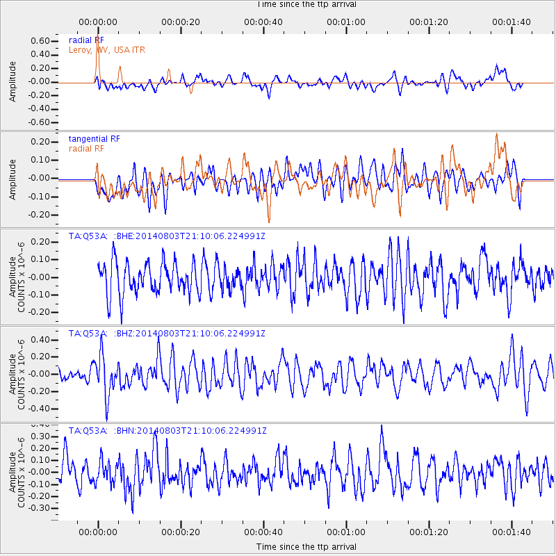
Q53A Leroy, WV, USA - Earthquake Result Viewer
*The percent match for this event was below the threshold and hence no stack was calculated.
| Earthquake location: |
Peru-Ecuador Border Region |
| Earthquake latitude/longitude: |
-3.9/-80.8 |
| Earthquake time(UTC): |
2014/08/03 (215) 21:02:46 GMT |
| Earthquake Depth: |
58 km |
| Earthquake Magnitude: |
5.5 MW, 4.4 mb, 4.5 mb1, 4.5 mb1mx, 4.7 mbtmp, 5.0 MS, 5.0 Ms1, 4.9 ms1mx |
| Earthquake Catalog/Contributor: |
ISC/ISC |
|
| Network: |
TA USArray Transportable Network (new EarthScope stations) |
| Station: |
Q53A Leroy, WV, USA |
| Lat/Lon: |
38.86 N/81.53 W |
| Elevation: |
310 m |
|
| Distance: |
42.5 deg |
| Az: |
359.142 deg |
| Baz: |
178.903 deg |
| Ray Param: |
$rayparam |
*The percent match for this event was below the threshold and hence was not used in the summary stack. |
|
| Radial Match: |
45.37994 % |
| Radial Bump: |
400 |
| Transverse Match: |
55.681465 % |
| Transverse Bump: |
400 |
| SOD ConfigId: |
3390531 |
| Insert Time: |
2019-04-13 04:54:01.702 +0000 |
| GWidth: |
2.5 |
| Max Bumps: |
400 |
| Tol: |
0.001 |
|
Signal To Noise
| Channel | StoN | STA | LTA |
| TA:Q53A: :BHZ:20140803T21:10:06.224991Z | 2.3569756 | 2.3698217E-7 | 1.0054503E-7 |
| TA:Q53A: :BHN:20140803T21:10:06.224991Z | 0.7289866 | 8.644266E-8 | 1.18579216E-7 |
| TA:Q53A: :BHE:20140803T21:10:06.224991Z | 0.6167123 | 5.4473112E-8 | 8.832824E-8 |
| Arrivals |
| Ps | |
| PpPs | |
| PsPs/PpSs | |


