You are here: Home > Network List > TA - USArray Transportable Network (new EarthScope stations) Stations List
> Station F41A Wisconsin Rapids, WI, USA > Earthquake Result Viewer
F41A Wisconsin Rapids, WI, USA - Earthquake Result Viewer
| Earthquake location: |
Off East Coast Of Kamchatka |
| Earthquake latitude/longitude: |
52.3/160.1 |
| Earthquake time(UTC): |
2013/05/19 (139) 18:44:10 GMT |
| Earthquake Depth: |
18 km |
| Earthquake Magnitude: |
6.1 MW, 5.8 MS, 5.9 MB, 5.9 MW |
| Earthquake Catalog/Contributor: |
NEIC PDE/NEIC PDE-W |
|
| Network: |
TA USArray Transportable Network (new EarthScope stations) |
| Station: |
F41A Wisconsin Rapids, WI, USA |
| Lat/Lon: |
45.74 N/89.10 W |
| Elevation: |
509 m |
|
| Distance: |
65.7 deg |
| Az: |
45.886 deg |
| Baz: |
321.025 deg |
| Ray Param: |
0.058056425 |
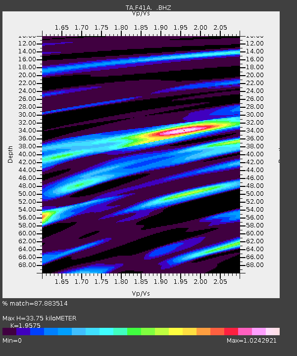
| Estimated Moho Depth: |
33.75 km |
| Estimated Crust Vp/Vs: |
1.96 |
| Assumed Crust Vp: |
6.41 km/s |
| Estimated Crust Vs: |
3.275 km/s |
| Estimated Crust Poisson's Ratio: |
0.32 |
|
| Radial Match: |
87.883514 % |
| Radial Bump: |
400 |
| Transverse Match: |
48.580627 % |
| Transverse Bump: |
400 |
| SOD ConfigId: |
512894 |
| Insert Time: |
2013-09-14 09:02:19.039 +0000 |
| GWidth: |
2.5 |
| Max Bumps: |
400 |
| Tol: |
0.001 |
|

Signal To Noise
| Channel | StoN | STA | LTA |
| TA:F41A: :BHZ:20130519T18:54:23.423999Z | 3.2547815 | 5.678501E-7 | 1.7446644E-7 |
| TA:F41A: :BHN:20130519T18:54:23.423999Z | 1.7651625 | 3.1477236E-7 | 1.7832487E-7 |
| TA:F41A: :BHE:20130519T18:54:23.423999Z | 1.3192071 | 2.1505403E-7 | 1.6301765E-7 |
| Arrivals |
| Ps | 5.2 SECOND |
| PpPs | 15 SECOND |
| PsPs/PpSs | 20 SECOND |


