You are here: Home > Network List > US - United States National Seismic Network Stations List
> Station AMTX Amarillo, Texas, USA > Earthquake Result Viewer
AMTX Amarillo, Texas, USA - Earthquake Result Viewer
*The percent match for this event was below the threshold and hence no stack was calculated.
| Earthquake location: |
Peru-Ecuador Border Region |
| Earthquake latitude/longitude: |
-3.9/-80.8 |
| Earthquake time(UTC): |
2014/08/03 (215) 21:02:46 GMT |
| Earthquake Depth: |
58 km |
| Earthquake Magnitude: |
5.5 MW, 4.4 mb, 4.5 mb1, 4.5 mb1mx, 4.7 mbtmp, 5.0 MS, 5.0 Ms1, 4.9 ms1mx |
| Earthquake Catalog/Contributor: |
ISC/ISC |
|
| Network: |
US United States National Seismic Network |
| Station: |
AMTX Amarillo, Texas, USA |
| Lat/Lon: |
34.53 N/101.41 W |
| Elevation: |
1010 m |
|
| Distance: |
42.9 deg |
| Az: |
334.695 deg |
| Baz: |
148.899 deg |
| Ray Param: |
$rayparam |
*The percent match for this event was below the threshold and hence was not used in the summary stack. |
|
| Radial Match: |
35.392323 % |
| Radial Bump: |
400 |
| Transverse Match: |
52.46484 % |
| Transverse Bump: |
400 |
| SOD ConfigId: |
3390531 |
| Insert Time: |
2019-04-13 04:54:45.441 +0000 |
| GWidth: |
2.5 |
| Max Bumps: |
400 |
| Tol: |
0.001 |
|
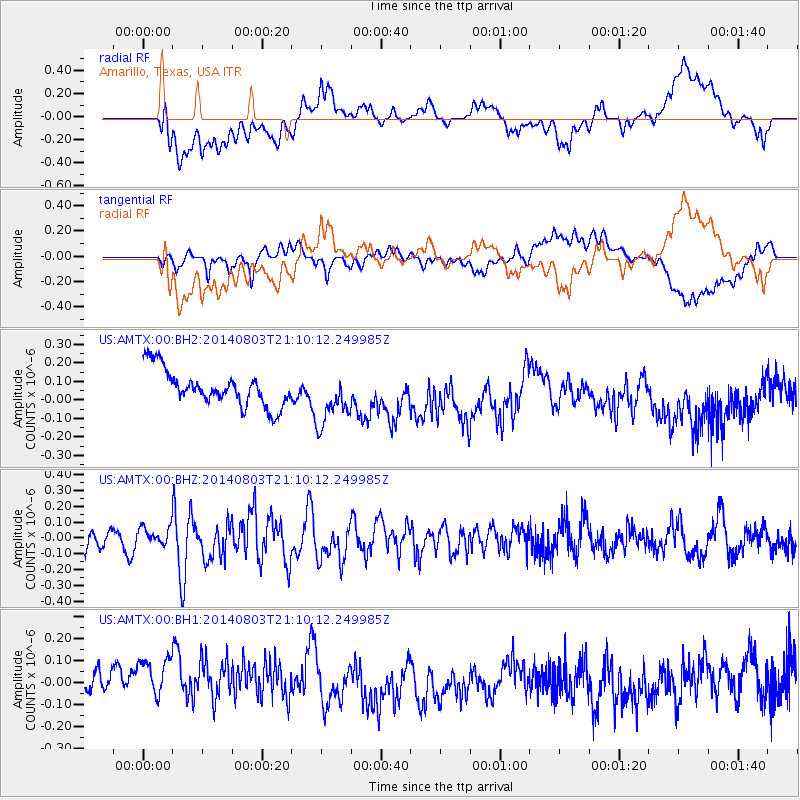
Signal To Noise
| Channel | StoN | STA | LTA |
| US:AMTX:00:BHZ:20140803T21:10:12.249985Z | 0.8669081 | 5.7924645E-8 | 6.681751E-8 |
| US:AMTX:00:BH1:20140803T21:10:12.249985Z | 1.3644073 | 1.9275208E-7 | 1.4127166E-7 |
| US:AMTX:00:BH2:20140803T21:10:12.249985Z | 1.659991 | 1.5082554E-7 | 9.085925E-8 |
| Arrivals |
| Ps | |
| PpPs | |
| PsPs/PpSs | |


