You are here: Home > Network List > TA - USArray Transportable Network (new EarthScope stations) Stations List
> Station J47A Sunmer, MI, USA > Earthquake Result Viewer
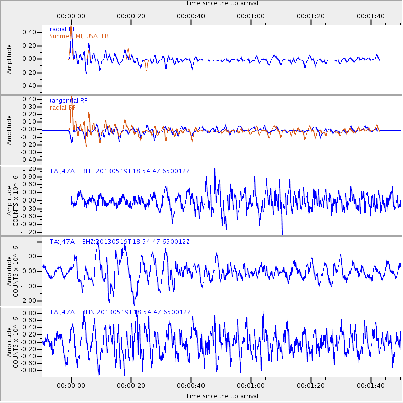
J47A Sunmer, MI, USA - Earthquake Result Viewer
*The percent match for this event was below the threshold and hence no stack was calculated.
| Earthquake location: |
Off East Coast Of Kamchatka |
| Earthquake latitude/longitude: |
52.3/160.1 |
| Earthquake time(UTC): |
2013/05/19 (139) 18:44:10 GMT |
| Earthquake Depth: |
18 km |
| Earthquake Magnitude: |
6.1 MW, 5.8 MS, 5.9 MB, 5.9 MW |
| Earthquake Catalog/Contributor: |
NEIC PDE/NEIC PDE-W |
|
| Network: |
TA USArray Transportable Network (new EarthScope stations) |
| Station: |
J47A Sunmer, MI, USA |
| Lat/Lon: |
43.24 N/84.82 W |
| Elevation: |
236 m |
|
| Distance: |
69.6 deg |
| Az: |
44.913 deg |
| Baz: |
323.647 deg |
| Ray Param: |
$rayparam |
*The percent match for this event was below the threshold and hence was not used in the summary stack. |
|
| Radial Match: |
63.194096 % |
| Radial Bump: |
400 |
| Transverse Match: |
64.91281 % |
| Transverse Bump: |
400 |
| SOD ConfigId: |
512894 |
| Insert Time: |
2013-09-14 09:05:26.593 +0000 |
| GWidth: |
2.5 |
| Max Bumps: |
400 |
| Tol: |
0.001 |
|
Signal To Noise
| Channel | StoN | STA | LTA |
| TA:J47A: :BHZ:20130519T18:54:47.650012Z | 3.1267953 | 6.31549E-7 | 2.0197966E-7 |
| TA:J47A: :BHN:20130519T18:54:47.650012Z | 2.0356293 | 4.174052E-7 | 2.0504972E-7 |
| TA:J47A: :BHE:20130519T18:54:47.650012Z | 2.6689196 | 3.7546502E-7 | 1.4068053E-7 |
| Arrivals |
| Ps | |
| PpPs | |
| PsPs/PpSs | |


