You are here: Home > Network List > TA - USArray Transportable Network (new EarthScope stations) Stations List
> Station K48A Perry, MI, USA > Earthquake Result Viewer
K48A Perry, MI, USA - Earthquake Result Viewer
| Earthquake location: |
Off East Coast Of Kamchatka |
| Earthquake latitude/longitude: |
52.3/160.1 |
| Earthquake time(UTC): |
2013/05/19 (139) 18:44:10 GMT |
| Earthquake Depth: |
18 km |
| Earthquake Magnitude: |
6.1 MW, 5.8 MS, 5.9 MB, 5.9 MW |
| Earthquake Catalog/Contributor: |
NEIC PDE/NEIC PDE-W |
|
| Network: |
TA USArray Transportable Network (new EarthScope stations) |
| Station: |
K48A Perry, MI, USA |
| Lat/Lon: |
42.80 N/84.12 W |
| Elevation: |
273 m |
|
| Distance: |
70.2 deg |
| Az: |
44.744 deg |
| Baz: |
324.066 deg |
| Ray Param: |
0.05509411 |
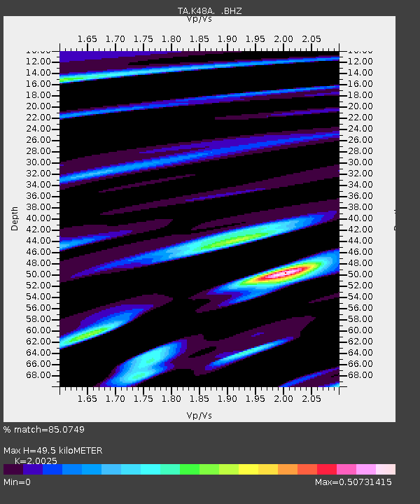
| Estimated Moho Depth: |
49.5 km |
| Estimated Crust Vp/Vs: |
2.00 |
| Assumed Crust Vp: |
6.483 km/s |
| Estimated Crust Vs: |
3.237 km/s |
| Estimated Crust Poisson's Ratio: |
0.33 |
|
| Radial Match: |
85.0749 % |
| Radial Bump: |
400 |
| Transverse Match: |
78.35844 % |
| Transverse Bump: |
400 |
| SOD ConfigId: |
512894 |
| Insert Time: |
2013-09-14 09:06:14.673 +0000 |
| GWidth: |
2.5 |
| Max Bumps: |
400 |
| Tol: |
0.001 |
|

Signal To Noise
| Channel | StoN | STA | LTA |
| TA:K48A: :BHZ:20130519T18:54:51.673999Z | 5.5356283 | 8.201005E-7 | 1.4814948E-7 |
| TA:K48A: :BHN:20130519T18:54:51.673999Z | 1.7542738 | 3.9202578E-7 | 2.2346899E-7 |
| TA:K48A: :BHE:20130519T18:54:51.673999Z | 1.7182306 | 2.668862E-7 | 1.5532618E-7 |
| Arrivals |
| Ps | 7.9 SECOND |
| PpPs | 22 SECOND |
| PsPs/PpSs | 30 SECOND |


