You are here: Home > Network List > US - United States National Seismic Network Stations List
> Station MNTX Cornudas Mountains, Texas, USA > Earthquake Result Viewer
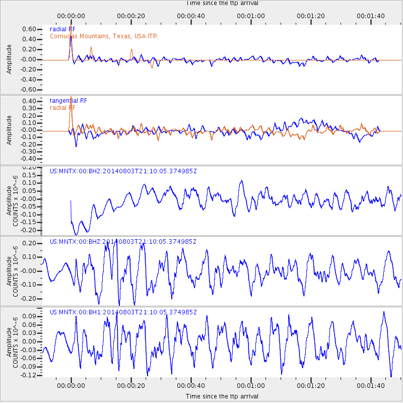
MNTX Cornudas Mountains, Texas, USA - Earthquake Result Viewer
*The percent match for this event was below the threshold and hence no stack was calculated.
| Earthquake location: |
Peru-Ecuador Border Region |
| Earthquake latitude/longitude: |
-3.9/-80.8 |
| Earthquake time(UTC): |
2014/08/03 (215) 21:02:46 GMT |
| Earthquake Depth: |
58 km |
| Earthquake Magnitude: |
5.5 MW, 4.4 mb, 4.5 mb1, 4.5 mb1mx, 4.7 mbtmp, 5.0 MS, 5.0 Ms1, 4.9 ms1mx |
| Earthquake Catalog/Contributor: |
ISC/ISC |
|
| Network: |
US United States National Seismic Network |
| Station: |
MNTX Cornudas Mountains, Texas, USA |
| Lat/Lon: |
31.70 N/105.38 W |
| Elevation: |
404 m |
|
| Distance: |
42.4 deg |
| Az: |
328.277 deg |
| Baz: |
142.015 deg |
| Ray Param: |
$rayparam |
*The percent match for this event was below the threshold and hence was not used in the summary stack. |
|
| Radial Match: |
55.712513 % |
| Radial Bump: |
400 |
| Transverse Match: |
28.758734 % |
| Transverse Bump: |
400 |
| SOD ConfigId: |
3390531 |
| Insert Time: |
2019-04-13 04:54:57.781 +0000 |
| GWidth: |
2.5 |
| Max Bumps: |
400 |
| Tol: |
0.001 |
|
Signal To Noise
| Channel | StoN | STA | LTA |
| US:MNTX:00:BHZ:20140803T21:10:05.374985Z | 1.0711113 | 6.5214174E-8 | 6.088459E-8 |
| US:MNTX:00:BH1:20140803T21:10:05.374985Z | 1.1665375 | 4.742965E-8 | 4.0658488E-8 |
| US:MNTX:00:BH2:20140803T21:10:05.374985Z | 1.2770879 | 1.0474533E-7 | 8.2018886E-8 |
| Arrivals |
| Ps | |
| PpPs | |
| PsPs/PpSs | |


