You are here: Home > Network List > TA - USArray Transportable Network (new EarthScope stations) Stations List
> Station M53A WI Miller and Sons, Farmdale, OH, USA > Earthquake Result Viewer
M53A WI Miller and Sons, Farmdale, OH, USA - Earthquake Result Viewer

| Earthquake location: |
Off East Coast Of Kamchatka |
| Earthquake latitude/longitude: |
52.3/160.1 |
| Earthquake time(UTC): |
2013/05/19 (139) 18:44:10 GMT |
| Earthquake Depth: |
18 km |
| Earthquake Magnitude: |
6.1 MW, 5.8 MS, 5.9 MB, 5.9 MW |
| Earthquake Catalog/Contributor: |
NEIC PDE/NEIC PDE-W |
|
| Network: |
TA USArray Transportable Network (new EarthScope stations) |
| Station: |
M53A WI Miller and Sons, Farmdale, OH, USA |
| Lat/Lon: |
41.44 N/80.68 W |
| Elevation: |
334 m |
|
| Distance: |
72.8 deg |
| Az: |
43.355 deg |
| Baz: |
325.929 deg |
| Ray Param: |
0.05338628 |
| Estimated Moho Depth: |
20.75 km |
| Estimated Crust Vp/Vs: |
1.89 |
| Assumed Crust Vp: |
6.483 km/s |
| Estimated Crust Vs: |
3.425 km/s |
| Estimated Crust Poisson's Ratio: |
0.31 |
|
| Radial Match: |
87.4933 % |
| Radial Bump: |
375 |
| Transverse Match: |
50.617905 % |
| Transverse Bump: |
400 |
| SOD ConfigId: |
512894 |
| Insert Time: |
2013-09-14 09:08:13.168 +0000 |
| GWidth: |
2.5 |
| Max Bumps: |
400 |
| Tol: |
0.001 |
|
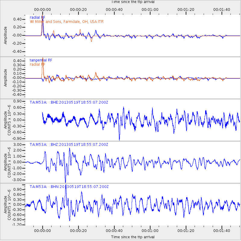
Signal To Noise
| Channel | StoN | STA | LTA |
| TA:M53A: :BHZ:20130519T18:55:07.200Z | 9.890686 | 9.803489E-7 | 9.911839E-8 |
| TA:M53A: :BHN:20130519T18:55:07.200Z | 2.764481 | 3.314294E-7 | 1.1988847E-7 |
| TA:M53A: :BHE:20130519T18:55:07.200Z | 1.6157253 | 2.3008026E-7 | 1.4240061E-7 |
| Arrivals |
| Ps | 3.0 SECOND |
| PpPs | 9.0 SECOND |
| PsPs/PpSs | 12 SECOND |


