You are here: Home > Network List > UW - Pacific Northwest Regional Seismic Network Stations List
> Station UMAT Pilot Rock, OR, USA > Earthquake Result Viewer
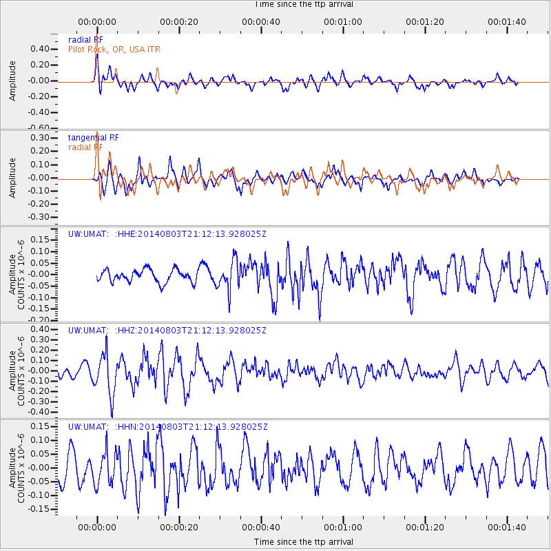
UMAT Pilot Rock, OR, USA - Earthquake Result Viewer
*The percent match for this event was below the threshold and hence no stack was calculated.
| Earthquake location: |
Peru-Ecuador Border Region |
| Earthquake latitude/longitude: |
-3.9/-80.8 |
| Earthquake time(UTC): |
2014/08/03 (215) 21:02:46 GMT |
| Earthquake Depth: |
58 km |
| Earthquake Magnitude: |
5.5 MW, 4.4 mb, 4.5 mb1, 4.5 mb1mx, 4.7 mbtmp, 5.0 MS, 5.0 Ms1, 4.9 ms1mx |
| Earthquake Catalog/Contributor: |
ISC/ISC |
|
| Network: |
UW Pacific Northwest Regional Seismic Network |
| Station: |
UMAT Pilot Rock, OR, USA |
| Lat/Lon: |
45.29 N/118.96 W |
| Elevation: |
1318 m |
|
| Distance: |
59.6 deg |
| Az: |
329.616 deg |
| Baz: |
134.366 deg |
| Ray Param: |
$rayparam |
*The percent match for this event was below the threshold and hence was not used in the summary stack. |
|
| Radial Match: |
53.182022 % |
| Radial Bump: |
400 |
| Transverse Match: |
52.590427 % |
| Transverse Bump: |
353 |
| SOD ConfigId: |
3390531 |
| Insert Time: |
2019-04-13 04:55:24.319 +0000 |
| GWidth: |
2.5 |
| Max Bumps: |
400 |
| Tol: |
0.001 |
|
Signal To Noise
| Channel | StoN | STA | LTA |
| UW:UMAT: :HHZ:20140803T21:12:13.928025Z | 4.726968 | 1.9672744E-7 | 4.1618108E-8 |
| UW:UMAT: :HHN:20140803T21:12:13.928025Z | 1.4619058 | 6.0812134E-8 | 4.1597847E-8 |
| UW:UMAT: :HHE:20140803T21:12:13.928025Z | 2.3443944 | 6.3496294E-8 | 2.7084305E-8 |
| Arrivals |
| Ps | |
| PpPs | |
| PsPs/PpSs | |


