You are here: Home > Network List > TA - USArray Transportable Network (new EarthScope stations) Stations List
> Station N48A Decatur, IN, USA > Earthquake Result Viewer
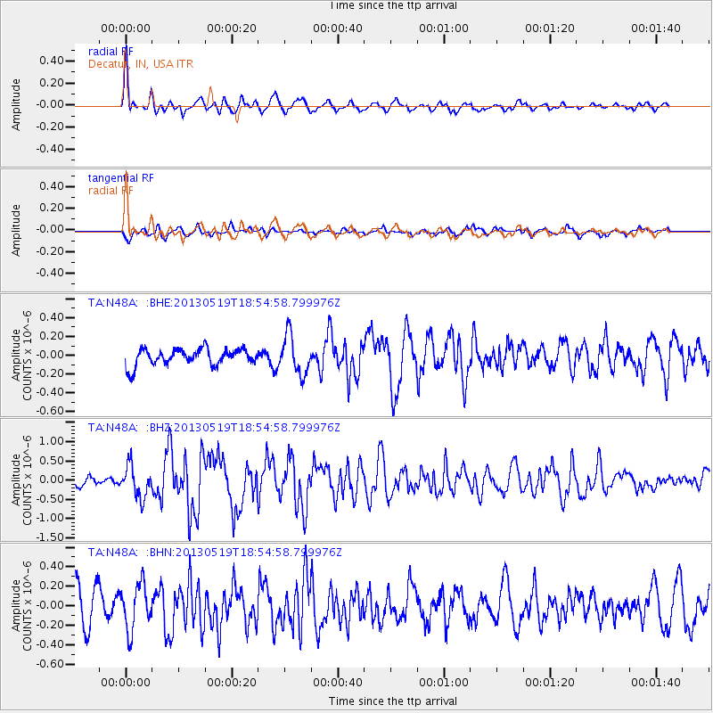
N48A Decatur, IN, USA - Earthquake Result Viewer
*The percent match for this event was below the threshold and hence no stack was calculated.
| Earthquake location: |
Off East Coast Of Kamchatka |
| Earthquake latitude/longitude: |
52.3/160.1 |
| Earthquake time(UTC): |
2013/05/19 (139) 18:44:10 GMT |
| Earthquake Depth: |
18 km |
| Earthquake Magnitude: |
6.1 MW, 5.8 MS, 5.9 MB, 5.9 MW |
| Earthquake Catalog/Contributor: |
NEIC PDE/NEIC PDE-W |
|
| Network: |
TA USArray Transportable Network (new EarthScope stations) |
| Station: |
N48A Decatur, IN, USA |
| Lat/Lon: |
40.86 N/85.03 W |
| Elevation: |
250 m |
|
| Distance: |
71.4 deg |
| Az: |
46.532 deg |
| Baz: |
324.05 deg |
| Ray Param: |
$rayparam |
*The percent match for this event was below the threshold and hence was not used in the summary stack. |
|
| Radial Match: |
71.30444 % |
| Radial Bump: |
370 |
| Transverse Match: |
70.07972 % |
| Transverse Bump: |
400 |
| SOD ConfigId: |
512894 |
| Insert Time: |
2013-09-14 09:09:01.040 +0000 |
| GWidth: |
2.5 |
| Max Bumps: |
400 |
| Tol: |
0.001 |
|
Signal To Noise
| Channel | StoN | STA | LTA |
| TA:N48A: :BHZ:20130519T18:54:58.799976Z | 3.2482548 | 4.174567E-7 | 1.2851723E-7 |
| TA:N48A: :BHN:20130519T18:54:58.799976Z | 1.2857846 | 2.3712154E-7 | 1.8441779E-7 |
| TA:N48A: :BHE:20130519T18:54:58.799976Z | 2.3877838 | 2.0979667E-7 | 8.786251E-8 |
| Arrivals |
| Ps | |
| PpPs | |
| PsPs/PpSs | |


