You are here: Home > Network List > TA - USArray Transportable Network (new EarthScope stations) Stations List
> Station N49A Columbus Grove, OH, USA > Earthquake Result Viewer
N49A Columbus Grove, OH, USA - Earthquake Result Viewer
| Earthquake location: |
Off East Coast Of Kamchatka |
| Earthquake latitude/longitude: |
52.3/160.1 |
| Earthquake time(UTC): |
2013/05/19 (139) 18:44:10 GMT |
| Earthquake Depth: |
18 km |
| Earthquake Magnitude: |
6.1 MW, 5.8 MS, 5.9 MB, 5.9 MW |
| Earthquake Catalog/Contributor: |
NEIC PDE/NEIC PDE-W |
|
| Network: |
TA USArray Transportable Network (new EarthScope stations) |
| Station: |
N49A Columbus Grove, OH, USA |
| Lat/Lon: |
40.92 N/84.18 W |
| Elevation: |
225 m |
|
| Distance: |
71.7 deg |
| Az: |
45.946 deg |
| Baz: |
324.416 deg |
| Ray Param: |
0.054107722 |
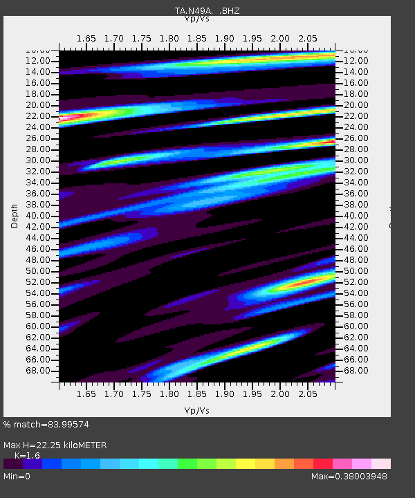
| Estimated Moho Depth: |
22.25 km |
| Estimated Crust Vp/Vs: |
1.60 |
| Assumed Crust Vp: |
6.498 km/s |
| Estimated Crust Vs: |
4.061 km/s |
| Estimated Crust Poisson's Ratio: |
0.18 |
|
| Radial Match: |
83.99574 % |
| Radial Bump: |
364 |
| Transverse Match: |
74.73346 % |
| Transverse Bump: |
400 |
| SOD ConfigId: |
512894 |
| Insert Time: |
2013-09-14 09:09:04.740 +0000 |
| GWidth: |
2.5 |
| Max Bumps: |
400 |
| Tol: |
0.001 |
|
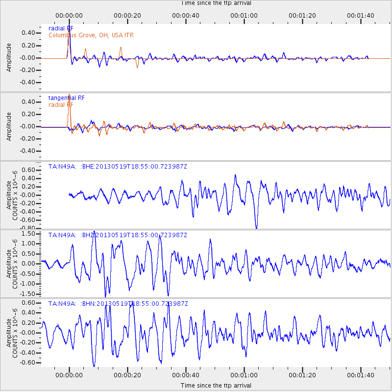
Signal To Noise
| Channel | StoN | STA | LTA |
| TA:N49A: :BHZ:20130519T18:55:00.723987Z | 3.7678642 | 5.476846E-7 | 1.4535678E-7 |
| TA:N49A: :BHN:20130519T18:55:00.723987Z | 1.4947801 | 1.9669831E-7 | 1.3159013E-7 |
| TA:N49A: :BHE:20130519T18:55:00.723987Z | 1.8145844 | 1.4438494E-7 | 7.9569155E-8 |
| Arrivals |
| Ps | 2.1 SECOND |
| PpPs | 8.6 SECOND |
| PsPs/PpSs | 11 SECOND |


