You are here: Home > Network List > TA - USArray Transportable Network (new EarthScope stations) Stations List
> Station O50A Cable, OH, USA > Earthquake Result Viewer
O50A Cable, OH, USA - Earthquake Result Viewer
| Earthquake location: |
Off East Coast Of Kamchatka |
| Earthquake latitude/longitude: |
52.3/160.1 |
| Earthquake time(UTC): |
2013/05/19 (139) 18:44:10 GMT |
| Earthquake Depth: |
18 km |
| Earthquake Magnitude: |
6.1 MW, 5.8 MS, 5.9 MB, 5.9 MW |
| Earthquake Catalog/Contributor: |
NEIC PDE/NEIC PDE-W |
|
| Network: |
TA USArray Transportable Network (new EarthScope stations) |
| Station: |
O50A Cable, OH, USA |
| Lat/Lon: |
40.15 N/83.62 W |
| Elevation: |
399 m |
|
| Distance: |
72.6 deg |
| Az: |
46.05 deg |
| Baz: |
324.812 deg |
| Ray Param: |
0.05352281 |
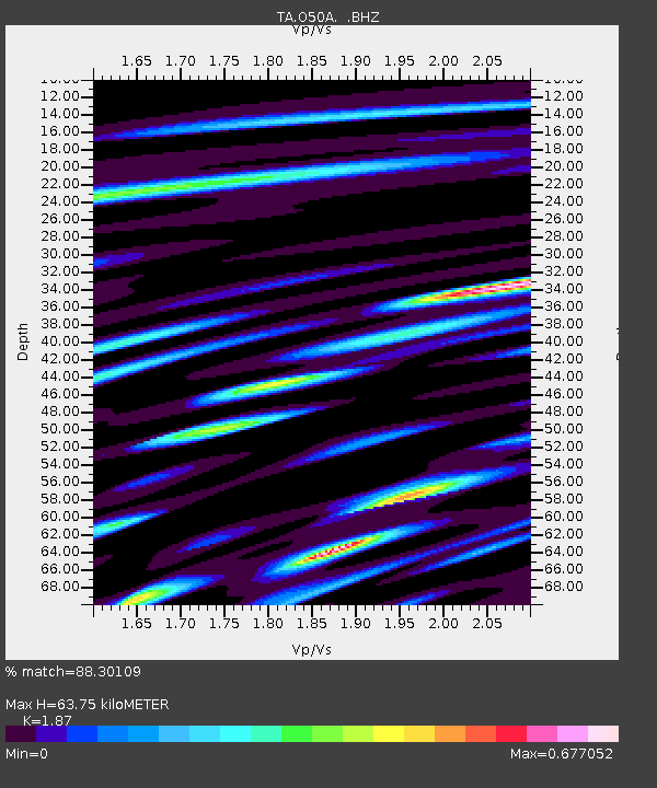
| Estimated Moho Depth: |
63.75 km |
| Estimated Crust Vp/Vs: |
1.87 |
| Assumed Crust Vp: |
6.498 km/s |
| Estimated Crust Vs: |
3.475 km/s |
| Estimated Crust Poisson's Ratio: |
0.30 |
|
| Radial Match: |
88.30109 % |
| Radial Bump: |
400 |
| Transverse Match: |
70.988914 % |
| Transverse Bump: |
400 |
| SOD ConfigId: |
512894 |
| Insert Time: |
2013-09-14 09:09:51.061 +0000 |
| GWidth: |
2.5 |
| Max Bumps: |
400 |
| Tol: |
0.001 |
|

Signal To Noise
| Channel | StoN | STA | LTA |
| TA:O50A: :BHZ:20130519T18:55:05.973987Z | 4.923001 | 5.5295317E-7 | 1.1232035E-7 |
| TA:O50A: :BHN:20130519T18:55:05.973987Z | 1.9241922 | 2.0927541E-7 | 1.0876015E-7 |
| TA:O50A: :BHE:20130519T18:55:05.973987Z | 2.469347 | 3.1651052E-7 | 1.281758E-7 |
| Arrivals |
| Ps | 8.8 SECOND |
| PpPs | 27 SECOND |
| PsPs/PpSs | 36 SECOND |


