You are here: Home > Network List > TA - USArray Transportable Network (new EarthScope stations) Stations List
> Station P54A Burton, WV, USA > Earthquake Result Viewer
P54A Burton, WV, USA - Earthquake Result Viewer
| Earthquake location: |
Off East Coast Of Kamchatka |
| Earthquake latitude/longitude: |
52.3/160.1 |
| Earthquake time(UTC): |
2013/05/19 (139) 18:44:10 GMT |
| Earthquake Depth: |
18 km |
| Earthquake Magnitude: |
6.1 MW, 5.8 MS, 5.9 MB, 5.9 MW |
| Earthquake Catalog/Contributor: |
NEIC PDE/NEIC PDE-W |
|
| Network: |
TA USArray Transportable Network (new EarthScope stations) |
| Station: |
P54A Burton, WV, USA |
| Lat/Lon: |
39.61 N/80.48 W |
| Elevation: |
473 m |
|
| Distance: |
74.4 deg |
| Az: |
44.288 deg |
| Baz: |
326.318 deg |
| Ray Param: |
0.05232137 |
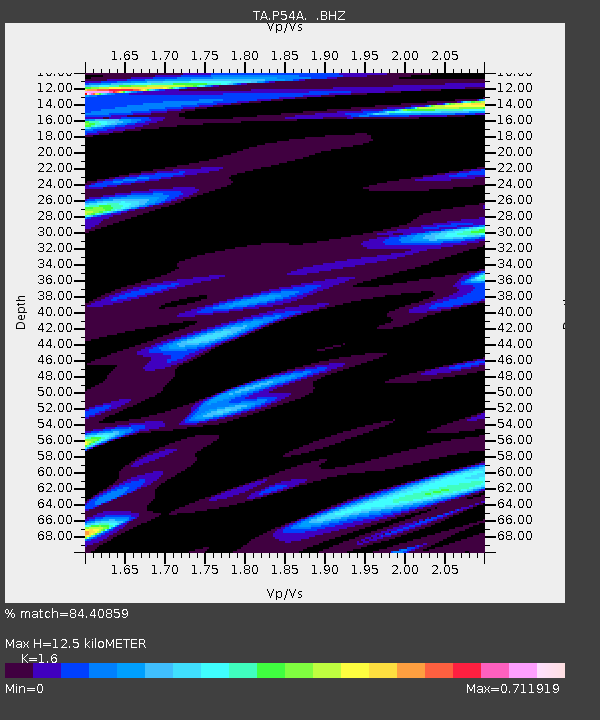
| Estimated Moho Depth: |
12.5 km |
| Estimated Crust Vp/Vs: |
1.60 |
| Assumed Crust Vp: |
6.207 km/s |
| Estimated Crust Vs: |
3.879 km/s |
| Estimated Crust Poisson's Ratio: |
0.18 |
|
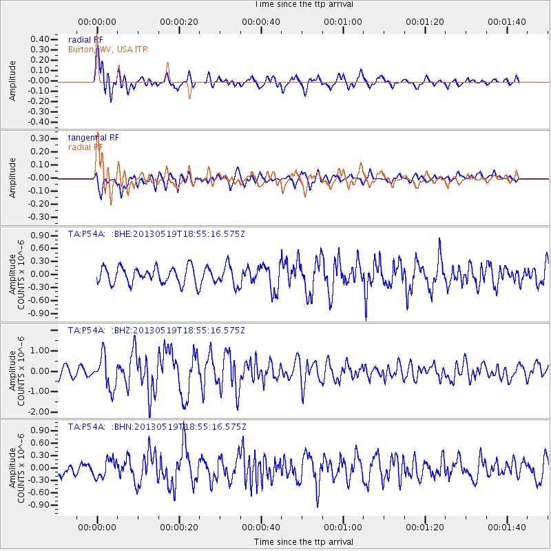
| Radial Match: |
84.40859 % |
| Radial Bump: |
400 |
| Transverse Match: |
70.27931 % |
| Transverse Bump: |
400 |
| SOD ConfigId: |
512894 |
| Insert Time: |
2013-09-14 09:10:53.383 +0000 |
| GWidth: |
2.5 |
| Max Bumps: |
400 |
| Tol: |
0.001 |
|
Signal To Noise
| Channel | StoN | STA | LTA |
| TA:P54A: :BHZ:20130519T18:55:16.575Z | 2.9636304 | 8.007467E-7 | 2.7019112E-7 |
| TA:P54A: :BHN:20130519T18:55:16.575Z | 1.740233 | 2.1817232E-7 | 1.2536961E-7 |
| TA:P54A: :BHE:20130519T18:55:16.575Z | 1.276917 | 2.4269139E-7 | 1.9006043E-7 |
| Arrivals |
| Ps | 1.3 SECOND |
| PpPs | 5.1 SECOND |
| PsPs/PpSs | 6.3 SECOND |


