You are here: Home > Network List > TA - USArray Transportable Network (new EarthScope stations) Stations List
> Station Q46A CEJHS Indians, Carlisle, IN, USA > Earthquake Result Viewer
Q46A CEJHS Indians, Carlisle, IN, USA - Earthquake Result Viewer
| Earthquake location: |
Off East Coast Of Kamchatka |
| Earthquake latitude/longitude: |
52.3/160.1 |
| Earthquake time(UTC): |
2013/05/19 (139) 18:44:10 GMT |
| Earthquake Depth: |
18 km |
| Earthquake Magnitude: |
6.1 MW, 5.8 MS, 5.9 MB, 5.9 MW |
| Earthquake Catalog/Contributor: |
NEIC PDE/NEIC PDE-W |
|
| Network: |
TA USArray Transportable Network (new EarthScope stations) |
| Station: |
Q46A CEJHS Indians, Carlisle, IN, USA |
| Lat/Lon: |
39.02 N/87.36 W |
| Elevation: |
164 m |
|
| Distance: |
71.8 deg |
| Az: |
49.197 deg |
| Baz: |
323.4 deg |
| Ray Param: |
0.05404432 |
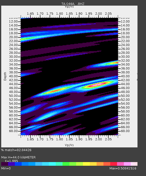
| Estimated Moho Depth: |
44.0 km |
| Estimated Crust Vp/Vs: |
2.00 |
| Assumed Crust Vp: |
6.444 km/s |
| Estimated Crust Vs: |
3.23 km/s |
| Estimated Crust Poisson's Ratio: |
0.33 |
|
| Radial Match: |
82.84426 % |
| Radial Bump: |
400 |
| Transverse Match: |
62.6736 % |
| Transverse Bump: |
400 |
| SOD ConfigId: |
512894 |
| Insert Time: |
2013-09-14 09:11:14.414 +0000 |
| GWidth: |
2.5 |
| Max Bumps: |
400 |
| Tol: |
0.001 |
|

Signal To Noise
| Channel | StoN | STA | LTA |
| TA:Q46A: :BHZ:20130519T18:55:01.299976Z | 2.6890545 | 5.4199853E-7 | 2.0155728E-7 |
| TA:Q46A: :BHN:20130519T18:55:01.299976Z | 0.9555482 | 2.0635764E-7 | 2.1595734E-7 |
| TA:Q46A: :BHE:20130519T18:55:01.299976Z | 1.1603222 | 2.0076904E-7 | 1.730287E-7 |
| Arrivals |
| Ps | 7.0 SECOND |
| PpPs | 20 SECOND |
| PsPs/PpSs | 27 SECOND |


