You are here: Home > Network List > TA - USArray Transportable Network (new EarthScope stations) Stations List
> Station S47A Hartford, KY, USA > Earthquake Result Viewer
S47A Hartford, KY, USA - Earthquake Result Viewer

| Earthquake location: |
Off East Coast Of Kamchatka |
| Earthquake latitude/longitude: |
52.3/160.1 |
| Earthquake time(UTC): |
2013/05/19 (139) 18:44:10 GMT |
| Earthquake Depth: |
18 km |
| Earthquake Magnitude: |
6.1 MW, 5.8 MS, 5.9 MB, 5.9 MW |
| Earthquake Catalog/Contributor: |
NEIC PDE/NEIC PDE-W |
|
| Network: |
TA USArray Transportable Network (new EarthScope stations) |
| Station: |
S47A Hartford, KY, USA |
| Lat/Lon: |
37.59 N/86.88 W |
| Elevation: |
181 m |
|
| Distance: |
73.2 deg |
| Az: |
49.765 deg |
| Baz: |
323.867 deg |
| Ray Param: |
0.053137984 |
| Estimated Moho Depth: |
41.0 km |
| Estimated Crust Vp/Vs: |
1.93 |
| Assumed Crust Vp: |
6.444 km/s |
| Estimated Crust Vs: |
3.339 km/s |
| Estimated Crust Poisson's Ratio: |
0.32 |
|
| Radial Match: |
82.29743 % |
| Radial Bump: |
400 |
| Transverse Match: |
70.06984 % |
| Transverse Bump: |
400 |
| SOD ConfigId: |
512894 |
| Insert Time: |
2013-09-14 09:12:58.676 +0000 |
| GWidth: |
2.5 |
| Max Bumps: |
400 |
| Tol: |
0.001 |
|
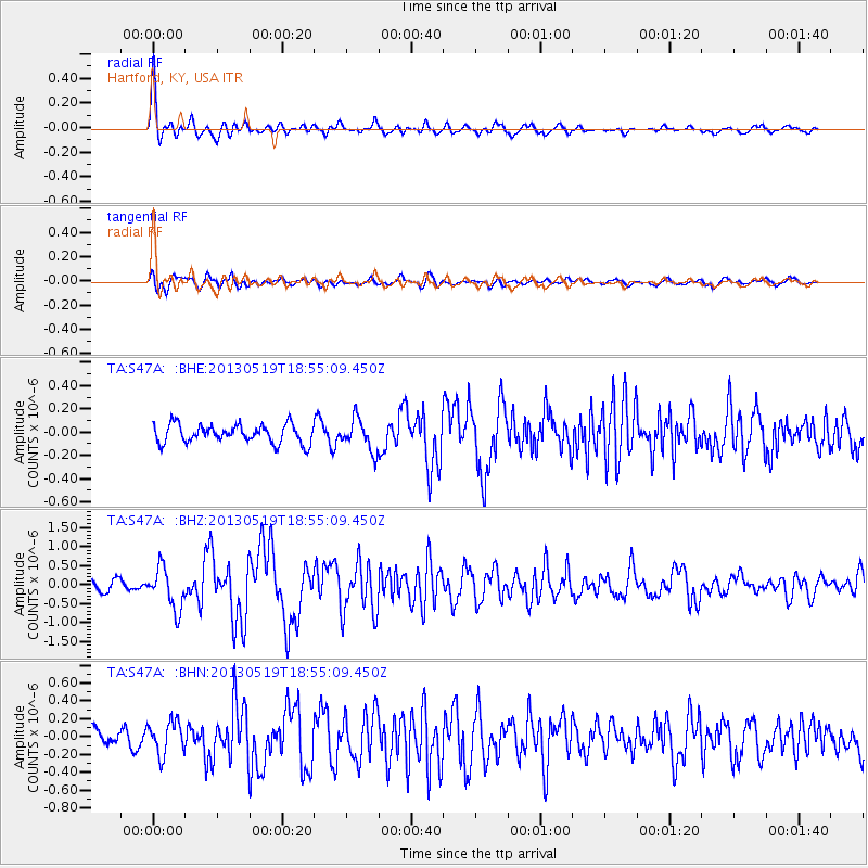
Signal To Noise
| Channel | StoN | STA | LTA |
| TA:S47A: :BHZ:20130519T18:55:09.450Z | 3.810551 | 5.4326404E-7 | 1.4256837E-7 |
| TA:S47A: :BHN:20130519T18:55:09.450Z | 1.6838014 | 1.8341213E-7 | 1.0892741E-7 |
| TA:S47A: :BHE:20130519T18:55:09.450Z | 1.7017426 | 1.3492726E-7 | 7.92877E-8 |
| Arrivals |
| Ps | 6.1 SECOND |
| PpPs | 18 SECOND |
| PsPs/PpSs | 24 SECOND |


