You are here: Home > Network List > TA - USArray Transportable Network (new EarthScope stations) Stations List
> Station S49A Springfield, KY, USA > Earthquake Result Viewer
S49A Springfield, KY, USA - Earthquake Result Viewer

| Earthquake location: |
Off East Coast Of Kamchatka |
| Earthquake latitude/longitude: |
52.3/160.1 |
| Earthquake time(UTC): |
2013/05/19 (139) 18:44:10 GMT |
| Earthquake Depth: |
18 km |
| Earthquake Magnitude: |
6.1 MW, 5.8 MS, 5.9 MB, 5.9 MW |
| Earthquake Catalog/Contributor: |
NEIC PDE/NEIC PDE-W |
|
| Network: |
TA USArray Transportable Network (new EarthScope stations) |
| Station: |
S49A Springfield, KY, USA |
| Lat/Lon: |
37.78 N/85.29 W |
| Elevation: |
230 m |
|
| Distance: |
73.8 deg |
| Az: |
48.583 deg |
| Baz: |
324.499 deg |
| Ray Param: |
0.052749842 |
| Estimated Moho Depth: |
44.75 km |
| Estimated Crust Vp/Vs: |
1.81 |
| Assumed Crust Vp: |
6.476 km/s |
| Estimated Crust Vs: |
3.583 km/s |
| Estimated Crust Poisson's Ratio: |
0.28 |
|
| Radial Match: |
86.97905 % |
| Radial Bump: |
374 |
| Transverse Match: |
66.96709 % |
| Transverse Bump: |
349 |
| SOD ConfigId: |
512894 |
| Insert Time: |
2013-09-14 09:13:04.220 +0000 |
| GWidth: |
2.5 |
| Max Bumps: |
400 |
| Tol: |
0.001 |
|
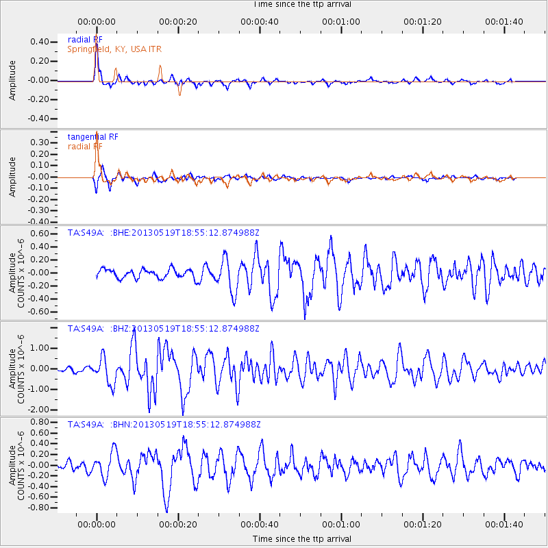
Signal To Noise
| Channel | StoN | STA | LTA |
| TA:S49A: :BHZ:20130519T18:55:12.874988Z | 5.1996193 | 6.492361E-7 | 1.2486223E-7 |
| TA:S49A: :BHN:20130519T18:55:12.874988Z | 3.0029533 | 2.393195E-7 | 7.96947E-8 |
| TA:S49A: :BHE:20130519T18:55:12.874988Z | 3.7946622 | 2.593633E-7 | 6.834951E-8 |
| Arrivals |
| Ps | 5.8 SECOND |
| PpPs | 19 SECOND |
| PsPs/PpSs | 25 SECOND |


