You are here: Home > Network List > TA - USArray Transportable Network (new EarthScope stations) Stations List
> Station T52A Hallie, KY, USA > Earthquake Result Viewer
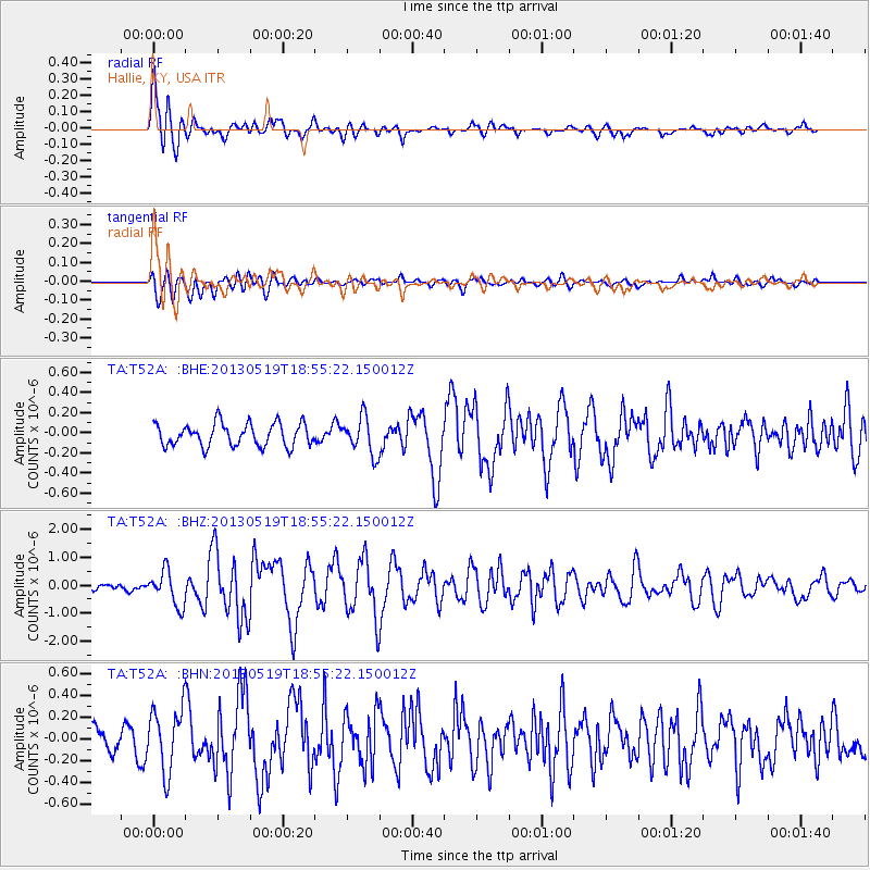
T52A Hallie, KY, USA - Earthquake Result Viewer
*The percent match for this event was below the threshold and hence no stack was calculated.
| Earthquake location: |
Off East Coast Of Kamchatka |
| Earthquake latitude/longitude: |
52.3/160.1 |
| Earthquake time(UTC): |
2013/05/19 (139) 18:44:10 GMT |
| Earthquake Depth: |
18 km |
| Earthquake Magnitude: |
6.1 MW, 5.8 MS, 5.9 MB, 5.9 MW |
| Earthquake Catalog/Contributor: |
NEIC PDE/NEIC PDE-W |
|
| Network: |
TA USArray Transportable Network (new EarthScope stations) |
| Station: |
T52A Hallie, KY, USA |
| Lat/Lon: |
37.11 N/82.99 W |
| Elevation: |
436 m |
|
| Distance: |
75.4 deg |
| Az: |
47.427 deg |
| Baz: |
325.586 deg |
| Ray Param: |
$rayparam |
*The percent match for this event was below the threshold and hence was not used in the summary stack. |
|
| Radial Match: |
76.47662 % |
| Radial Bump: |
400 |
| Transverse Match: |
68.00308 % |
| Transverse Bump: |
400 |
| SOD ConfigId: |
512894 |
| Insert Time: |
2013-09-14 09:14:11.355 +0000 |
| GWidth: |
2.5 |
| Max Bumps: |
400 |
| Tol: |
0.001 |
|
Signal To Noise
| Channel | StoN | STA | LTA |
| TA:T52A: :BHZ:20130519T18:55:22.150012Z | 3.224588 | 6.219293E-7 | 1.9287094E-7 |
| TA:T52A: :BHN:20130519T18:55:22.150012Z | 2.8246224 | 2.9143064E-7 | 1.0317508E-7 |
| TA:T52A: :BHE:20130519T18:55:22.150012Z | 1.6393218 | 1.8318771E-7 | 1.1174604E-7 |
| Arrivals |
| Ps | |
| PpPs | |
| PsPs/PpSs | |


