You are here: Home > Network List > TA - USArray Transportable Network (new EarthScope stations) Stations List
> Station TUL1 Leonard, OK, USA > Earthquake Result Viewer
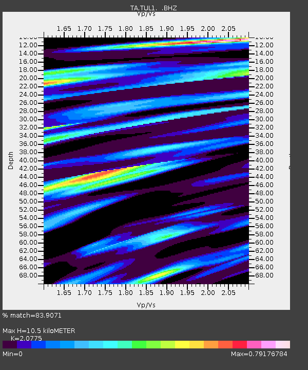
TUL1 Leonard, OK, USA - Earthquake Result Viewer
| Earthquake location: |
Off East Coast Of Kamchatka |
| Earthquake latitude/longitude: |
52.3/160.1 |
| Earthquake time(UTC): |
2013/05/19 (139) 18:44:10 GMT |
| Earthquake Depth: |
18 km |
| Earthquake Magnitude: |
6.1 MW, 5.8 MS, 5.9 MB, 5.9 MW |
| Earthquake Catalog/Contributor: |
NEIC PDE/NEIC PDE-W |
|
| Network: |
TA USArray Transportable Network (new EarthScope stations) |
| Station: |
TUL1 Leonard, OK, USA |
| Lat/Lon: |
35.91 N/95.79 W |
| Elevation: |
256 m |
|
| Distance: |
70.2 deg |
| Az: |
56.811 deg |
| Baz: |
320.766 deg |
| Ray Param: |
0.05515167 |
| Estimated Moho Depth: |
10.5 km |
| Estimated Crust Vp/Vs: |
2.08 |
| Assumed Crust Vp: |
6.498 km/s |
| Estimated Crust Vs: |
3.128 km/s |
| Estimated Crust Poisson's Ratio: |
0.35 |
|
| Radial Match: |
83.9071 % |
| Radial Bump: |
374 |
| Transverse Match: |
68.21238 % |
| Transverse Bump: |
400 |
| SOD ConfigId: |
512894 |
| Insert Time: |
2013-09-14 09:14:53.019 +0000 |
| GWidth: |
2.5 |
| Max Bumps: |
400 |
| Tol: |
0.001 |
|

Signal To Noise
| Channel | StoN | STA | LTA |
| TA:TUL1: :BHZ:20130519T18:54:51.124988Z | 2.9621212 | 3.2424555E-7 | 1.0946397E-7 |
| TA:TUL1: :BHN:20130519T18:54:51.124988Z | 1.7146773 | 1.7238048E-7 | 1.0053232E-7 |
| TA:TUL1: :BHE:20130519T18:54:51.124988Z | 2.2531176 | 1.7734793E-7 | 7.871225E-8 |
| Arrivals |
| Ps | 1.8 SECOND |
| PpPs | 4.8 SECOND |
| PsPs/PpSs | 6.6 SECOND |


