You are here: Home > Network List > TA - USArray Transportable Network (new EarthScope stations) Stations List
> Station U50A Jamestown, TN, USA > Earthquake Result Viewer
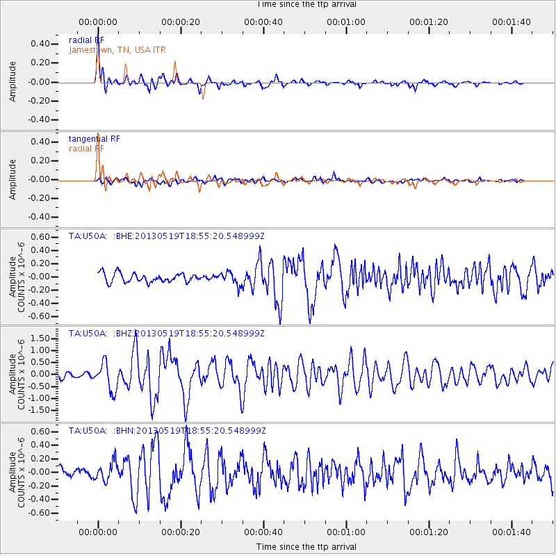
U50A Jamestown, TN, USA - Earthquake Result Viewer

| Earthquake location: |
Off East Coast Of Kamchatka |
| Earthquake latitude/longitude: |
52.3/160.1 |
| Earthquake time(UTC): |
2013/05/19 (139) 18:44:10 GMT |
| Earthquake Depth: |
18 km |
| Earthquake Magnitude: |
6.1 MW, 5.8 MS, 5.9 MB, 5.9 MW |
| Earthquake Catalog/Contributor: |
NEIC PDE/NEIC PDE-W |
|
| Network: |
TA USArray Transportable Network (new EarthScope stations) |
| Station: |
U50A Jamestown, TN, USA |
| Lat/Lon: |
36.42 N/84.84 W |
| Elevation: |
474 m |
|
| Distance: |
75.1 deg |
| Az: |
49.101 deg |
| Baz: |
324.905 deg |
| Ray Param: |
0.051866975 |
| Estimated Moho Depth: |
52.25 km |
| Estimated Crust Vp/Vs: |
1.85 |
| Assumed Crust Vp: |
6.476 km/s |
| Estimated Crust Vs: |
3.496 km/s |
| Estimated Crust Poisson's Ratio: |
0.29 |
|
| Radial Match: |
90.2884 % |
| Radial Bump: |
383 |
| Transverse Match: |
73.052444 % |
| Transverse Bump: |
400 |
| SOD ConfigId: |
512894 |
| Insert Time: |
2013-09-14 09:15:12.164 +0000 |
| GWidth: |
2.5 |
| Max Bumps: |
400 |
| Tol: |
0.001 |
|
Signal To Noise
| Channel | StoN | STA | LTA |
| TA:U50A: :BHZ:20130519T18:55:20.548999Z | 4.4382935 | 5.874257E-7 | 1.3235396E-7 |
| TA:U50A: :BHN:20130519T18:55:20.548999Z | 1.876838 | 1.3848903E-7 | 7.3788485E-8 |
| TA:U50A: :BHE:20130519T18:55:20.548999Z | 1.4617077 | 9.8059346E-8 | 6.7085466E-8 |
| Arrivals |
| Ps | 7.1 SECOND |
| PpPs | 22 SECOND |
| PsPs/PpSs | 29 SECOND |


