You are here: Home > Network List > TA - USArray Transportable Network (new EarthScope stations) Stations List
> Station W54A Cherokee Point, Campobello, SC, USA > Earthquake Result Viewer
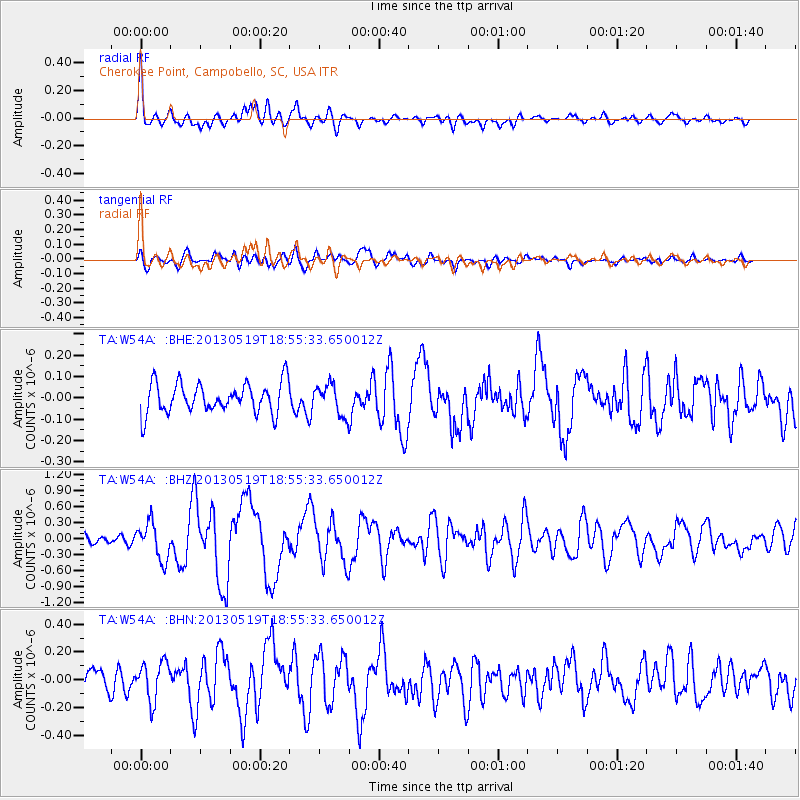
W54A Cherokee Point, Campobello, SC, USA - Earthquake Result Viewer
| Earthquake location: |
Off East Coast Of Kamchatka |
| Earthquake latitude/longitude: |
52.3/160.1 |
| Earthquake time(UTC): |
2013/05/19 (139) 18:44:10 GMT |
| Earthquake Depth: |
18 km |
| Earthquake Magnitude: |
6.1 MW, 5.8 MS, 5.9 MB, 5.9 MW |
| Earthquake Catalog/Contributor: |
NEIC PDE/NEIC PDE-W |
|
| Network: |
TA USArray Transportable Network (new EarthScope stations) |
| Station: |
W54A Cherokee Point, Campobello, SC, USA |
| Lat/Lon: |
35.09 N/82.19 W |
| Elevation: |
272 m |
|
| Distance: |
77.4 deg |
| Az: |
48.039 deg |
| Baz: |
326.199 deg |
| Ray Param: |
0.050310984 |
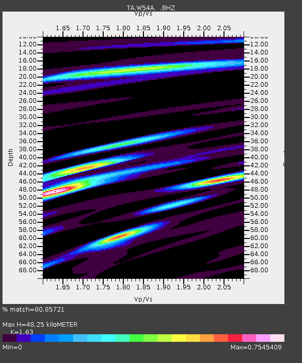
| Estimated Moho Depth: |
48.25 km |
| Estimated Crust Vp/Vs: |
1.63 |
| Assumed Crust Vp: |
6.35 km/s |
| Estimated Crust Vs: |
3.896 km/s |
| Estimated Crust Poisson's Ratio: |
0.20 |
|
| Radial Match: |
80.85721 % |
| Radial Bump: |
400 |
| Transverse Match: |
72.525314 % |
| Transverse Bump: |
400 |
| SOD ConfigId: |
512894 |
| Insert Time: |
2013-09-14 09:17:15.301 +0000 |
| GWidth: |
2.5 |
| Max Bumps: |
400 |
| Tol: |
0.001 |
|
Signal To Noise
| Channel | StoN | STA | LTA |
| TA:W54A: :BHZ:20130519T18:55:33.650012Z | 3.8014295 | 3.4058033E-7 | 8.95927E-8 |
| TA:W54A: :BHN:20130519T18:55:33.650012Z | 1.8252038 | 1.4050897E-7 | 7.698263E-8 |
| TA:W54A: :BHE:20130519T18:55:33.650012Z | 0.99244696 | 7.0407644E-8 | 7.0943486E-8 |
| Arrivals |
| Ps | 4.9 SECOND |
| PpPs | 19 SECOND |
| PsPs/PpSs | 24 SECOND |


