You are here: Home > Network List > TA - USArray Transportable Network (new EarthScope stations) Stations List
> Station X49A Woodville, AR, USA > Earthquake Result Viewer
X49A Woodville, AR, USA - Earthquake Result Viewer
| Earthquake location: |
Off East Coast Of Kamchatka |
| Earthquake latitude/longitude: |
52.3/160.1 |
| Earthquake time(UTC): |
2013/05/19 (139) 18:44:10 GMT |
| Earthquake Depth: |
18 km |
| Earthquake Magnitude: |
6.1 MW, 5.8 MS, 5.9 MB, 5.9 MW |
| Earthquake Catalog/Contributor: |
NEIC PDE/NEIC PDE-W |
|
| Network: |
TA USArray Transportable Network (new EarthScope stations) |
| Station: |
X49A Woodville, AR, USA |
| Lat/Lon: |
34.51 N/86.33 W |
| Elevation: |
182 m |
|
| Distance: |
76.0 deg |
| Az: |
51.254 deg |
| Baz: |
324.586 deg |
| Ray Param: |
0.051295605 |
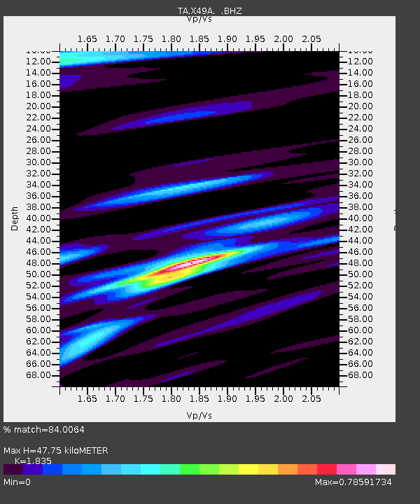
| Estimated Moho Depth: |
47.75 km |
| Estimated Crust Vp/Vs: |
1.84 |
| Assumed Crust Vp: |
6.476 km/s |
| Estimated Crust Vs: |
3.529 km/s |
| Estimated Crust Poisson's Ratio: |
0.29 |
|
| Radial Match: |
84.0064 % |
| Radial Bump: |
400 |
| Transverse Match: |
66.0933 % |
| Transverse Bump: |
400 |
| SOD ConfigId: |
512894 |
| Insert Time: |
2013-09-14 09:17:52.467 +0000 |
| GWidth: |
2.5 |
| Max Bumps: |
400 |
| Tol: |
0.001 |
|

Signal To Noise
| Channel | StoN | STA | LTA |
| TA:X49A: :BHZ:20130519T18:55:25.400012Z | 5.3882565 | 4.2144055E-7 | 7.821464E-8 |
| TA:X49A: :BHN:20130519T18:55:25.400012Z | 1.8983043 | 1.2234159E-7 | 6.4447825E-8 |
| TA:X49A: :BHE:20130519T18:55:25.400012Z | 1.7683748 | 1.3748085E-7 | 7.774418E-8 |
| Arrivals |
| Ps | 6.4 SECOND |
| PpPs | 20 SECOND |
| PsPs/PpSs | 27 SECOND |


