You are here: Home > Network List > TA - USArray Transportable Network (new EarthScope stations) Stations List
> Station X53A Estanollee, GA, USA > Earthquake Result Viewer
X53A Estanollee, GA, USA - Earthquake Result Viewer
| Earthquake location: |
Off East Coast Of Kamchatka |
| Earthquake latitude/longitude: |
52.3/160.1 |
| Earthquake time(UTC): |
2013/05/19 (139) 18:44:10 GMT |
| Earthquake Depth: |
18 km |
| Earthquake Magnitude: |
6.1 MW, 5.8 MS, 5.9 MB, 5.9 MW |
| Earthquake Catalog/Contributor: |
NEIC PDE/NEIC PDE-W |
|
| Network: |
TA USArray Transportable Network (new EarthScope stations) |
| Station: |
X53A Estanollee, GA, USA |
| Lat/Lon: |
34.50 N/83.30 W |
| Elevation: |
240 m |
|
| Distance: |
77.4 deg |
| Az: |
49.152 deg |
| Baz: |
325.808 deg |
| Ray Param: |
0.05033238 |
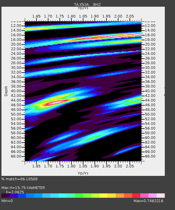
| Estimated Moho Depth: |
15.75 km |
| Estimated Crust Vp/Vs: |
2.06 |
| Assumed Crust Vp: |
6.35 km/s |
| Estimated Crust Vs: |
3.079 km/s |
| Estimated Crust Poisson's Ratio: |
0.35 |
|
| Radial Match: |
86.18588 % |
| Radial Bump: |
389 |
| Transverse Match: |
63.24901 % |
| Transverse Bump: |
400 |
| SOD ConfigId: |
512894 |
| Insert Time: |
2013-09-14 09:17:59.123 +0000 |
| GWidth: |
2.5 |
| Max Bumps: |
400 |
| Tol: |
0.001 |
|

Signal To Noise
| Channel | StoN | STA | LTA |
| TA:X53A: :BHZ:20130519T18:55:33.475024Z | 3.6896951 | 5.290065E-7 | 1.4337405E-7 |
| TA:X53A: :BHN:20130519T18:55:33.475024Z | 1.840313 | 1.737156E-7 | 9.43946E-8 |
| TA:X53A: :BHE:20130519T18:55:33.475024Z | 0.77584374 | 8.393913E-8 | 1.0819076E-7 |
| Arrivals |
| Ps | 2.7 SECOND |
| PpPs | 7.4 SECOND |
| PsPs/PpSs | 10 SECOND |


