You are here: Home > Network List > TA - USArray Transportable Network (new EarthScope stations) Stations List
> Station X54A Belton, SC, USA > Earthquake Result Viewer
X54A Belton, SC, USA - Earthquake Result Viewer

| Earthquake location: |
Off East Coast Of Kamchatka |
| Earthquake latitude/longitude: |
52.3/160.1 |
| Earthquake time(UTC): |
2013/05/19 (139) 18:44:10 GMT |
| Earthquake Depth: |
18 km |
| Earthquake Magnitude: |
6.1 MW, 5.8 MS, 5.9 MB, 5.9 MW |
| Earthquake Catalog/Contributor: |
NEIC PDE/NEIC PDE-W |
|
| Network: |
TA USArray Transportable Network (new EarthScope stations) |
| Station: |
X54A Belton, SC, USA |
| Lat/Lon: |
34.55 N/82.37 W |
| Elevation: |
213 m |
|
| Distance: |
77.8 deg |
| Az: |
48.477 deg |
| Baz: |
326.186 deg |
| Ray Param: |
0.05006586 |
| Estimated Moho Depth: |
56.0 km |
| Estimated Crust Vp/Vs: |
1.98 |
| Assumed Crust Vp: |
6.35 km/s |
| Estimated Crust Vs: |
3.215 km/s |
| Estimated Crust Poisson's Ratio: |
0.33 |
|
| Radial Match: |
81.67845 % |
| Radial Bump: |
400 |
| Transverse Match: |
65.29149 % |
| Transverse Bump: |
400 |
| SOD ConfigId: |
512894 |
| Insert Time: |
2013-09-14 09:18:03.901 +0000 |
| GWidth: |
2.5 |
| Max Bumps: |
400 |
| Tol: |
0.001 |
|
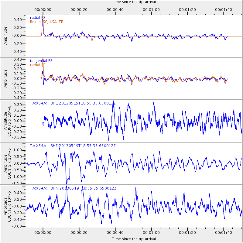
Signal To Noise
| Channel | StoN | STA | LTA |
| TA:X54A: :BHZ:20130519T18:55:35.650012Z | 7.0453844 | 4.9696854E-7 | 7.053817E-8 |
| TA:X54A: :BHN:20130519T18:55:35.650012Z | 2.8610783 | 1.7645995E-7 | 6.167603E-8 |
| TA:X54A: :BHE:20130519T18:55:35.650012Z | 1.1720177 | 8.814778E-8 | 7.521029E-8 |
| Arrivals |
| Ps | 8.8 SECOND |
| PpPs | 26 SECOND |
| PsPs/PpSs | 34 SECOND |


