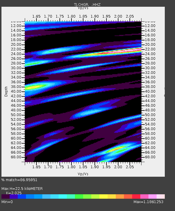
CHGR Chuyangaron, Tajikistan - Earthquake Result Viewer

Earthquake location: Off East Coast Of Kamchatka
Earthquake latitude/longitude: 52.3/160.1
Earthquake time(UTC): 2013/05/19 (139) 18:44:10 GMT
Earthquake Depth: 18 km
Earthquake Magnitude: 6.1 MW, 5.8 MS, 5.9 MB, 5.9 MW
Earthquake Catalog/Contributor: NEIC PDE/NEIC PDE-W
Network: TJ Tajikistan National Seismic Network
Station: CHGR Chuyangaron, Tajikistan
Lat/Lon: 38.66 N/69.16 E
Elevation: 1049 m
Distance: 61.1 deg
Az: 296.568 deg
Baz: 44.499 deg
Ray Param: 0.061092142
Estimated Moho Depth: 22.5 km
Estimated Crust Vp/Vs: 2.03
Assumed Crust Vp: 6.483 km/s
Estimated Crust Vs: 3.201 km/s
Estimated Crust Poisson's Ratio: 0.34
Radial Match: 86.95951 %
Radial Bump: 400
Transverse Match: 75.53558 %
Transverse Bump: 400
SOD ConfigId: 512894
Insert Time: 2013-09-14 09:19:53.371 +0000
GWidth: 2.5
Max Bumps: 400
Tol: 0.001

Signal To Noise

ChannelStoNSTALTA
TJ:CHGR: :HHZ:20130519T18:53:52.619983Z14.5245311.7871197E-61.2304147E-7
TJ:CHGR: :HHN:20130519T18:53:52.619983Z6.79020365.960933E-78.778725E-8
TJ:CHGR: :HHE:20130519T18:53:52.619983Z5.87900263.8397147E-76.531235E-8
Arrivals
Ps3.7 SECOND
PpPs10 SECOND
PsPs/PpSs14 SECOND