You are here: Home > Network List > US - United States National Seismic Network Stations List
> Station DGMT Dagmar, Montana, USA > Earthquake Result Viewer
DGMT Dagmar, Montana, USA - Earthquake Result Viewer
*The percent match for this event was below the threshold and hence no stack was calculated.
| Earthquake location: |
Off East Coast Of Kamchatka |
| Earthquake latitude/longitude: |
52.3/160.1 |
| Earthquake time(UTC): |
2013/05/19 (139) 18:44:10 GMT |
| Earthquake Depth: |
18 km |
| Earthquake Magnitude: |
6.1 MW, 5.8 MS, 5.9 MB, 5.9 MW |
| Earthquake Catalog/Contributor: |
NEIC PDE/NEIC PDE-W |
|
| Network: |
US United States National Seismic Network |
| Station: |
DGMT Dagmar, Montana, USA |
| Lat/Lon: |
48.47 N/104.20 W |
| Elevation: |
0.0 m |
|
| Distance: |
56.7 deg |
| Az: |
52.369 deg |
| Baz: |
313.103 deg |
| Ray Param: |
$rayparam |
*The percent match for this event was below the threshold and hence was not used in the summary stack. |
|
| Radial Match: |
78.05301 % |
| Radial Bump: |
400 |
| Transverse Match: |
61.00735 % |
| Transverse Bump: |
400 |
| SOD ConfigId: |
512894 |
| Insert Time: |
2013-09-14 09:21:11.850 +0000 |
| GWidth: |
2.5 |
| Max Bumps: |
400 |
| Tol: |
0.001 |
|
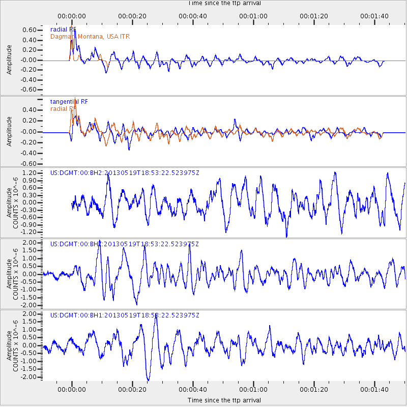
Signal To Noise
| Channel | StoN | STA | LTA |
| US:DGMT:00:BHZ:20130519T18:53:22.523975Z | 4.301862 | 4.6692648E-7 | 1.08540554E-7 |
| US:DGMT:00:BH1:20130519T18:53:22.523975Z | 1.3726511 | 3.0433793E-7 | 2.2171542E-7 |
| US:DGMT:00:BH2:20130519T18:53:22.523975Z | 0.76466715 | 2.9471326E-7 | 3.8541378E-7 |
| Arrivals |
| Ps | |
| PpPs | |
| PsPs/PpSs | |


