You are here: Home > Network List > GO - National Seismic Network of Georgia Stations List
> Station TBLG Delisi, Georgia > Earthquake Result Viewer
TBLG Delisi, Georgia - Earthquake Result Viewer

| Earthquake location: |
Off East Coast Of Kamchatka |
| Earthquake latitude/longitude: |
52.3/160.3 |
| Earthquake time(UTC): |
2013/05/20 (140) 00:13:17 GMT |
| Earthquake Depth: |
35 km |
| Earthquake Magnitude: |
5.5 MW, 5.5 MB |
| Earthquake Catalog/Contributor: |
NEIC PDE/NEIC PDE-W |
|
| Network: |
GO National Seismic Network of Georgia |
| Station: |
TBLG Delisi, Georgia |
| Lat/Lon: |
41.73 N/44.74 E |
| Elevation: |
510 m |
|
| Distance: |
71.1 deg |
| Az: |
314.429 deg |
| Baz: |
35.909 deg |
| Ray Param: |
0.0545228 |
| Estimated Moho Depth: |
69.75 km |
| Estimated Crust Vp/Vs: |
1.76 |
| Assumed Crust Vp: |
6.291 km/s |
| Estimated Crust Vs: |
3.569 km/s |
| Estimated Crust Poisson's Ratio: |
0.26 |
|
| Radial Match: |
80.26161 % |
| Radial Bump: |
400 |
| Transverse Match: |
75.55912 % |
| Transverse Bump: |
400 |
| SOD ConfigId: |
512894 |
| Insert Time: |
2013-09-14 09:37:56.447 +0000 |
| GWidth: |
2.5 |
| Max Bumps: |
400 |
| Tol: |
0.001 |
|
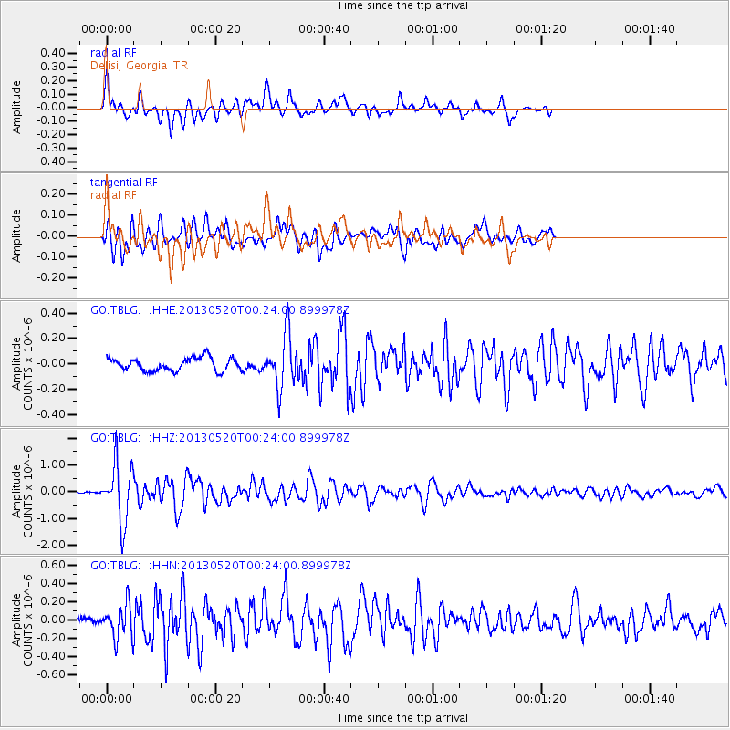
Signal To Noise
| Channel | StoN | STA | LTA |
| GO:TBLG: :HHZ:20130520T00:24:00.899978Z | 17.106815 | 1.0858039E-6 | 6.347201E-8 |
| GO:TBLG: :HHN:20130520T00:24:00.899978Z | 3.1756032 | 1.8195732E-7 | 5.7298507E-8 |
| GO:TBLG: :HHE:20130520T00:24:00.899978Z | 4.1715894 | 2.0997666E-7 | 5.033493E-8 |
| Arrivals |
| Ps | 8.8 SECOND |
| PpPs | 30 SECOND |
| PsPs/PpSs | 38 SECOND |


