You are here: Home > Network List > NE - New England Seismic Network Stations List
> Station EMMW Machias, ME, USA > Earthquake Result Viewer
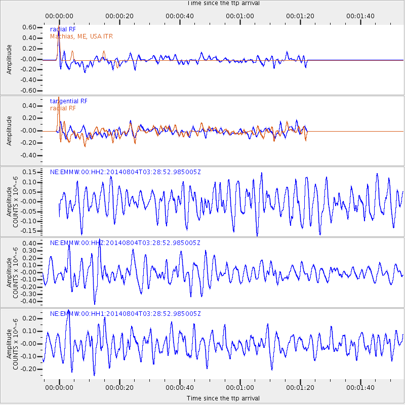
EMMW Machias, ME, USA - Earthquake Result Viewer
*The percent match for this event was below the threshold and hence no stack was calculated.
| Earthquake location: |
Near Coast Of Northern Peru |
| Earthquake latitude/longitude: |
-6.9/-81.6 |
| Earthquake time(UTC): |
2014/08/04 (216) 03:20:09 GMT |
| Earthquake Depth: |
23 km |
| Earthquake Magnitude: |
5.3 MW, 5.4 mb, 5.3 Mwb |
| Earthquake Catalog/Contributor: |
ISC/ISC |
|
| Network: |
NE New England Seismic Network |
| Station: |
EMMW Machias, ME, USA |
| Lat/Lon: |
44.71 N/67.46 W |
| Elevation: |
35 m |
|
| Distance: |
52.9 deg |
| Az: |
12.616 deg |
| Baz: |
197.704 deg |
| Ray Param: |
$rayparam |
*The percent match for this event was below the threshold and hence was not used in the summary stack. |
|
| Radial Match: |
59.28993 % |
| Radial Bump: |
400 |
| Transverse Match: |
45.441723 % |
| Transverse Bump: |
400 |
| SOD ConfigId: |
3390531 |
| Insert Time: |
2019-04-13 05:03:13.969 +0000 |
| GWidth: |
2.5 |
| Max Bumps: |
400 |
| Tol: |
0.001 |
|
Signal To Noise
| Channel | StoN | STA | LTA |
| NE:EMMW:00:HHZ:20140804T03:28:52.985005Z | 2.2895775 | 1.5201393E-7 | 6.639387E-8 |
| NE:EMMW:00:HH1:20140804T03:28:52.985005Z | 2.019225 | 1.3762147E-7 | 6.8155586E-8 |
| NE:EMMW:00:HH2:20140804T03:28:52.985005Z | 0.79569185 | 4.5947093E-8 | 5.774483E-8 |
| Arrivals |
| Ps | |
| PpPs | |
| PsPs/PpSs | |


