You are here: Home > Network List > TA - USArray Transportable Network (new EarthScope stations) Stations List
> Station D46A Sault St. Marie, ON, CAN > Earthquake Result Viewer
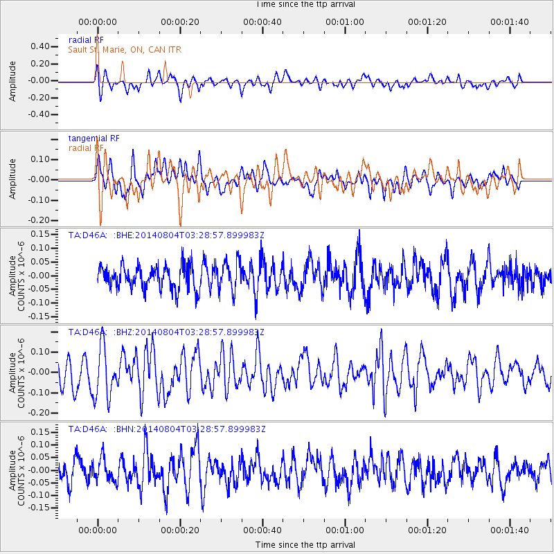
D46A Sault St. Marie, ON, CAN - Earthquake Result Viewer
*The percent match for this event was below the threshold and hence no stack was calculated.
| Earthquake location: |
Near Coast Of Northern Peru |
| Earthquake latitude/longitude: |
-6.9/-81.6 |
| Earthquake time(UTC): |
2014/08/04 (216) 03:20:09 GMT |
| Earthquake Depth: |
23 km |
| Earthquake Magnitude: |
5.3 MW, 5.4 mb, 5.3 Mwb |
| Earthquake Catalog/Contributor: |
ISC/ISC |
|
| Network: |
TA USArray Transportable Network (new EarthScope stations) |
| Station: |
D46A Sault St. Marie, ON, CAN |
| Lat/Lon: |
46.89 N/84.04 W |
| Elevation: |
353 m |
|
| Distance: |
53.6 deg |
| Az: |
357.931 deg |
| Baz: |
177.004 deg |
| Ray Param: |
$rayparam |
*The percent match for this event was below the threshold and hence was not used in the summary stack. |
|
| Radial Match: |
55.581326 % |
| Radial Bump: |
400 |
| Transverse Match: |
47.024147 % |
| Transverse Bump: |
400 |
| SOD ConfigId: |
3390531 |
| Insert Time: |
2019-04-13 05:05:09.830 +0000 |
| GWidth: |
2.5 |
| Max Bumps: |
400 |
| Tol: |
0.001 |
|
Signal To Noise
| Channel | StoN | STA | LTA |
| TA:D46A: :BHZ:20140804T03:28:57.899983Z | 1.7190099 | 1.2644239E-7 | 7.3555356E-8 |
| TA:D46A: :BHN:20140804T03:28:57.899983Z | 1.1685307 | 4.6119077E-8 | 3.946758E-8 |
| TA:D46A: :BHE:20140804T03:28:57.899983Z | 1.291502 | 5.373632E-8 | 4.1607613E-8 |
| Arrivals |
| Ps | |
| PpPs | |
| PsPs/PpSs | |


