You are here: Home > Network List > TA - USArray Transportable Network (new EarthScope stations) Stations List
> Station E64A Bridgewater, ME, USA > Earthquake Result Viewer
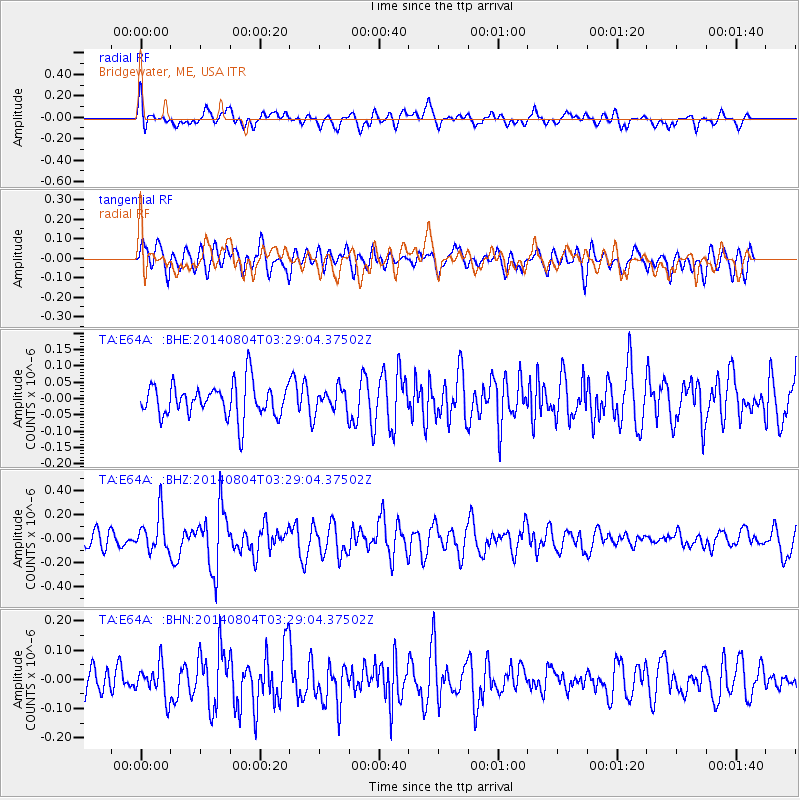
E64A Bridgewater, ME, USA - Earthquake Result Viewer
*The percent match for this event was below the threshold and hence no stack was calculated.
| Earthquake location: |
Near Coast Of Northern Peru |
| Earthquake latitude/longitude: |
-6.9/-81.6 |
| Earthquake time(UTC): |
2014/08/04 (216) 03:20:09 GMT |
| Earthquake Depth: |
23 km |
| Earthquake Magnitude: |
5.3 MW, 5.4 mb, 5.3 Mwb |
| Earthquake Catalog/Contributor: |
ISC/ISC |
|
| Network: |
TA USArray Transportable Network (new EarthScope stations) |
| Station: |
E64A Bridgewater, ME, USA |
| Lat/Lon: |
46.42 N/67.83 W |
| Elevation: |
190 m |
|
| Distance: |
54.5 deg |
| Az: |
11.676 deg |
| Baz: |
196.884 deg |
| Ray Param: |
$rayparam |
*The percent match for this event was below the threshold and hence was not used in the summary stack. |
|
| Radial Match: |
66.40764 % |
| Radial Bump: |
400 |
| Transverse Match: |
61.332363 % |
| Transverse Bump: |
400 |
| SOD ConfigId: |
3390531 |
| Insert Time: |
2019-04-13 05:05:28.372 +0000 |
| GWidth: |
2.5 |
| Max Bumps: |
400 |
| Tol: |
0.001 |
|
Signal To Noise
| Channel | StoN | STA | LTA |
| TA:E64A: :BHZ:20140804T03:29:04.37502Z | 2.200181 | 1.583864E-7 | 7.19879E-8 |
| TA:E64A: :BHN:20140804T03:29:04.37502Z | 1.1648864 | 5.6750302E-8 | 4.871746E-8 |
| TA:E64A: :BHE:20140804T03:29:04.37502Z | 0.6882648 | 3.5593278E-8 | 5.1714515E-8 |
| Arrivals |
| Ps | |
| PpPs | |
| PsPs/PpSs | |


