You are here: Home > Network List > TA - USArray Transportable Network (new EarthScope stations) Stations List
> Station G59A Clarenceville, QC, USA > Earthquake Result Viewer
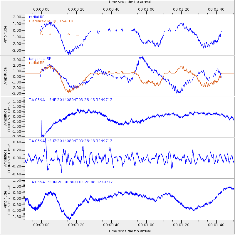
G59A Clarenceville, QC, USA - Earthquake Result Viewer
*The percent match for this event was below the threshold and hence no stack was calculated.
| Earthquake location: |
Near Coast Of Northern Peru |
| Earthquake latitude/longitude: |
-6.9/-81.6 |
| Earthquake time(UTC): |
2014/08/04 (216) 03:20:09 GMT |
| Earthquake Depth: |
23 km |
| Earthquake Magnitude: |
5.3 MW, 5.4 mb, 5.3 Mwb |
| Earthquake Catalog/Contributor: |
ISC/ISC |
|
| Network: |
TA USArray Transportable Network (new EarthScope stations) |
| Station: |
G59A Clarenceville, QC, USA |
| Lat/Lon: |
45.08 N/73.18 W |
| Elevation: |
36 m |
|
| Distance: |
52.3 deg |
| Az: |
7.538 deg |
| Baz: |
190.593 deg |
| Ray Param: |
$rayparam |
*The percent match for this event was below the threshold and hence was not used in the summary stack. |
|
| Radial Match: |
22.989363 % |
| Radial Bump: |
400 |
| Transverse Match: |
47.60342 % |
| Transverse Bump: |
400 |
| SOD ConfigId: |
3390531 |
| Insert Time: |
2019-04-13 05:05:38.572 +0000 |
| GWidth: |
2.5 |
| Max Bumps: |
400 |
| Tol: |
0.001 |
|
Signal To Noise
| Channel | StoN | STA | LTA |
| TA:G59A: :BHZ:20140804T03:28:48.324971Z | 3.19356 | 2.0953044E-7 | 6.561031E-8 |
| TA:G59A: :BHN:20140804T03:28:48.324971Z | 1.0418662 | 1.2652819E-6 | 1.2144379E-6 |
| TA:G59A: :BHE:20140804T03:28:48.324971Z | 0.9811499 | 7.8005155E-7 | 7.950381E-7 |
| Arrivals |
| Ps | |
| PpPs | |
| PsPs/PpSs | |


