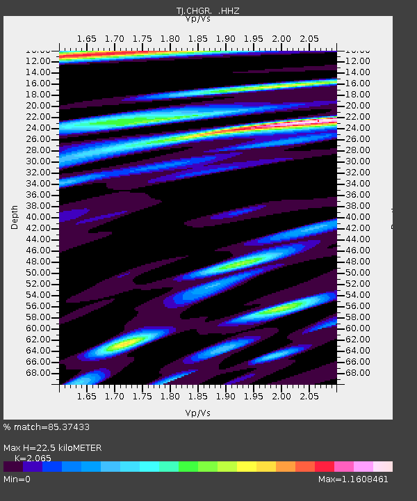
CHGR Chuyangaron, Tajikistan - Earthquake Result Viewer

Earthquake location: Off East Coast Of Kamchatka
Earthquake latitude/longitude: 52.5/160.4
Earthquake time(UTC): 2013/05/21 (141) 01:55:08 GMT
Earthquake Depth: 30 km
Earthquake Magnitude: 6.0 MW, 5.6 MB, 5.7 MS, 5.9 MW
Earthquake Catalog/Contributor: NEIC PDE/NEIC PDE-W
Network: TJ Tajikistan National Seismic Network
Station: CHGR Chuyangaron, Tajikistan
Lat/Lon: 38.66 N/69.16 E
Elevation: 1049 m
Distance: 61.2 deg
Az: 296.669 deg
Baz: 44.222 deg
Ray Param: 0.06100765
Estimated Moho Depth: 22.5 km
Estimated Crust Vp/Vs: 2.07
Assumed Crust Vp: 6.483 km/s
Estimated Crust Vs: 3.139 km/s
Estimated Crust Poisson's Ratio: 0.35
Radial Match: 85.37433 %
Radial Bump: 400
Transverse Match: 77.380135 %
Transverse Bump: 400
SOD ConfigId: 512894
Insert Time: 2013-09-14 11:13:19.024 +0000
GWidth: 2.5
Max Bumps: 400
Tol: 0.001

Signal To Noise

ChannelStoNSTALTA
TJ:CHGR: :HHZ:20130521T02:04:49.17002Z5.89171748.7656923E-71.4877992E-7
TJ:CHGR: :HHN:20130521T02:04:49.17002Z3.53333663.8123787E-71.0789741E-7
TJ:CHGR: :HHE:20130521T02:04:49.17002Z4.40814922.7682086E-76.2797525E-8
Arrivals
Ps3.8 SECOND
PpPs10 SECOND
PsPs/PpSs14 SECOND