You are here: Home > Network List > TA - USArray Transportable Network (new EarthScope stations) Stations List
> Station M51A Elyria, OH, USA > Earthquake Result Viewer
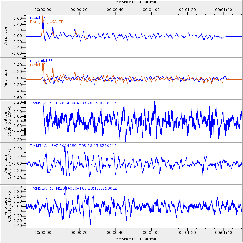
M51A Elyria, OH, USA - Earthquake Result Viewer
*The percent match for this event was below the threshold and hence no stack was calculated.
| Earthquake location: |
Near Coast Of Northern Peru |
| Earthquake latitude/longitude: |
-6.9/-81.6 |
| Earthquake time(UTC): |
2014/08/04 (216) 03:20:09 GMT |
| Earthquake Depth: |
23 km |
| Earthquake Magnitude: |
5.3 MW, 5.4 mb, 5.3 Mwb |
| Earthquake Catalog/Contributor: |
ISC/ISC |
|
| Network: |
TA USArray Transportable Network (new EarthScope stations) |
| Station: |
M51A Elyria, OH, USA |
| Lat/Lon: |
41.33 N/82.18 W |
| Elevation: |
239 m |
|
| Distance: |
48.0 deg |
| Az: |
359.416 deg |
| Baz: |
179.23 deg |
| Ray Param: |
$rayparam |
*The percent match for this event was below the threshold and hence was not used in the summary stack. |
|
| Radial Match: |
64.000435 % |
| Radial Bump: |
400 |
| Transverse Match: |
57.884846 % |
| Transverse Bump: |
400 |
| SOD ConfigId: |
3390531 |
| Insert Time: |
2019-04-13 05:06:20.071 +0000 |
| GWidth: |
2.5 |
| Max Bumps: |
400 |
| Tol: |
0.001 |
|
Signal To Noise
| Channel | StoN | STA | LTA |
| TA:M51A: :BHZ:20140804T03:28:15.825001Z | 2.1821342 | 1.7252621E-7 | 7.9063064E-8 |
| TA:M51A: :BHN:20140804T03:28:15.825001Z | 1.5675701 | 8.9163905E-8 | 5.688033E-8 |
| TA:M51A: :BHE:20140804T03:28:15.825001Z | 1.1885476 | 6.761438E-8 | 5.6888236E-8 |
| Arrivals |
| Ps | |
| PpPs | |
| PsPs/PpSs | |


