You are here: Home > Network List > TA - USArray Transportable Network (new EarthScope stations) Stations List
> Station O03E Paynes Creek, CA, USA > Earthquake Result Viewer
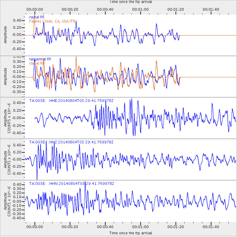
O03E Paynes Creek, CA, USA - Earthquake Result Viewer
*The percent match for this event was below the threshold and hence no stack was calculated.
| Earthquake location: |
Near Coast Of Northern Peru |
| Earthquake latitude/longitude: |
-6.9/-81.6 |
| Earthquake time(UTC): |
2014/08/04 (216) 03:20:09 GMT |
| Earthquake Depth: |
23 km |
| Earthquake Magnitude: |
5.3 MW, 5.4 mb, 5.3 Mwb |
| Earthquake Catalog/Contributor: |
ISC/ISC |
|
| Network: |
TA USArray Transportable Network (new EarthScope stations) |
| Station: |
O03E Paynes Creek, CA, USA |
| Lat/Lon: |
40.29 N/121.80 W |
| Elevation: |
967 m |
|
| Distance: |
59.8 deg |
| Az: |
325.17 deg |
| Baz: |
132.153 deg |
| Ray Param: |
$rayparam |
*The percent match for this event was below the threshold and hence was not used in the summary stack. |
|
| Radial Match: |
59.154163 % |
| Radial Bump: |
400 |
| Transverse Match: |
59.64079 % |
| Transverse Bump: |
400 |
| SOD ConfigId: |
3390531 |
| Insert Time: |
2019-04-13 05:06:34.041 +0000 |
| GWidth: |
2.5 |
| Max Bumps: |
400 |
| Tol: |
0.001 |
|
Signal To Noise
| Channel | StoN | STA | LTA |
| TA:O03E: :HHZ:20140804T03:29:41.769978Z | 3.4112155 | 2.1132628E-7 | 6.195043E-8 |
| TA:O03E: :HHN:20140804T03:29:41.769978Z | 1.3220971 | 9.808773E-8 | 7.419103E-8 |
| TA:O03E: :HHE:20140804T03:29:41.769978Z | 2.0222955 | 1.5040177E-7 | 7.437181E-8 |
| Arrivals |
| Ps | |
| PpPs | |
| PsPs/PpSs | |


