You are here: Home > Network List > IU - Global Seismograph Network (GSN - IRIS/USGS) Stations List
> Station TEIG Tepich, Yucatan, Mexico > Earthquake Result Viewer
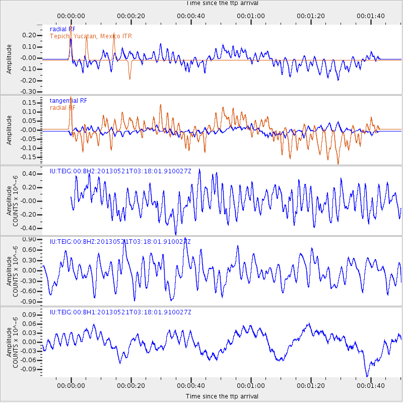
TEIG Tepich, Yucatan, Mexico - Earthquake Result Viewer
*The percent match for this event was below the threshold and hence no stack was calculated.
| Earthquake location: |
Off East Coast Of Kamchatka |
| Earthquake latitude/longitude: |
52.4/160.3 |
| Earthquake time(UTC): |
2013/05/21 (141) 03:05:50 GMT |
| Earthquake Depth: |
11 km |
| Earthquake Magnitude: |
5.9 MW, 5.5 MB, 5.8 MS, 5.8 MW |
| Earthquake Catalog/Contributor: |
NEIC PDE/NEIC PDE-W |
|
| Network: |
IU Global Seismograph Network (GSN - IRIS/USGS) |
| Station: |
TEIG Tepich, Yucatan, Mexico |
| Lat/Lon: |
20.23 N/88.28 W |
| Elevation: |
40 m |
|
| Distance: |
86.5 deg |
| Az: |
61.141 deg |
| Baz: |
325.144 deg |
| Ray Param: |
$rayparam |
*The percent match for this event was below the threshold and hence was not used in the summary stack. |
|
| Radial Match: |
50.78173 % |
| Radial Bump: |
400 |
| Transverse Match: |
44.20545 % |
| Transverse Bump: |
400 |
| SOD ConfigId: |
512894 |
| Insert Time: |
2013-09-14 11:32:19.336 +0000 |
| GWidth: |
2.5 |
| Max Bumps: |
400 |
| Tol: |
0.001 |
|
Signal To Noise
| Channel | StoN | STA | LTA |
| IU:TEIG:00:BHZ:20130521T03:18:01.910027Z | 0.6951716 | 1.8699923E-7 | 2.6899724E-7 |
| IU:TEIG:00:BH1:20130521T03:18:01.910027Z | 1.7767607 | 3.6174917E-8 | 2.0360039E-8 |
| IU:TEIG:00:BH2:20130521T03:18:01.910027Z | 1.6530188 | 2.7103505E-7 | 1.6396368E-7 |
| Arrivals |
| Ps | |
| PpPs | |
| PsPs/PpSs | |


