You are here: Home > Network List > TA - USArray Transportable Network (new EarthScope stations) Stations List
> Station TUL1 Leonard, OK, USA > Earthquake Result Viewer
TUL1 Leonard, OK, USA - Earthquake Result Viewer
| Earthquake location: |
Near Coast Of Northern Peru |
| Earthquake latitude/longitude: |
-6.9/-81.6 |
| Earthquake time(UTC): |
2014/08/04 (216) 03:20:09 GMT |
| Earthquake Depth: |
23 km |
| Earthquake Magnitude: |
5.3 MW, 5.4 mb, 5.3 Mwb |
| Earthquake Catalog/Contributor: |
ISC/ISC |
|
| Network: |
TA USArray Transportable Network (new EarthScope stations) |
| Station: |
TUL1 Leonard, OK, USA |
| Lat/Lon: |
35.91 N/95.79 W |
| Elevation: |
256 m |
|
| Distance: |
44.6 deg |
| Az: |
343.554 deg |
| Baz: |
159.742 deg |
| Ray Param: |
0.071756475 |
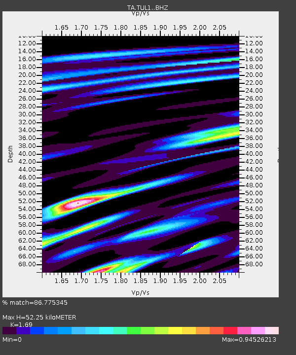
| Estimated Moho Depth: |
52.25 km |
| Estimated Crust Vp/Vs: |
1.69 |
| Assumed Crust Vp: |
6.498 km/s |
| Estimated Crust Vs: |
3.845 km/s |
| Estimated Crust Poisson's Ratio: |
0.23 |
|
| Radial Match: |
86.775345 % |
| Radial Bump: |
400 |
| Transverse Match: |
75.05684 % |
| Transverse Bump: |
400 |
| SOD ConfigId: |
3390531 |
| Insert Time: |
2019-04-13 05:07:01.599 +0000 |
| GWidth: |
2.5 |
| Max Bumps: |
400 |
| Tol: |
0.001 |
|

Signal To Noise
| Channel | StoN | STA | LTA |
| TA:TUL1: :BHZ:20140804T03:27:49.349995Z | 5.6647615 | 3.6570356E-7 | 6.4557625E-8 |
| TA:TUL1: :BHN:20140804T03:27:49.349995Z | 4.2597246 | 2.066197E-7 | 4.8505413E-8 |
| TA:TUL1: :BHE:20140804T03:27:49.349995Z | 2.077037 | 8.535717E-8 | 4.1095642E-8 |
| Arrivals |
| Ps | 5.9 SECOND |
| PpPs | 20 SECOND |
| PsPs/PpSs | 26 SECOND |


