You are here: Home > Network List > TA - USArray Transportable Network (new EarthScope stations) Stations List
> Station 249A Camden, AL, USA > Earthquake Result Viewer
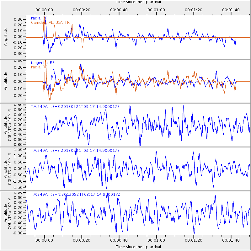
249A Camden, AL, USA - Earthquake Result Viewer
*The percent match for this event was below the threshold and hence no stack was calculated.
| Earthquake location: |
Off East Coast Of Kamchatka |
| Earthquake latitude/longitude: |
52.4/160.3 |
| Earthquake time(UTC): |
2013/05/21 (141) 03:05:50 GMT |
| Earthquake Depth: |
11 km |
| Earthquake Magnitude: |
5.9 MW, 5.5 MB, 5.8 MS, 5.8 MW |
| Earthquake Catalog/Contributor: |
NEIC PDE/NEIC PDE-W |
|
| Network: |
TA USArray Transportable Network (new EarthScope stations) |
| Station: |
249A Camden, AL, USA |
| Lat/Lon: |
31.98 N/87.12 W |
| Elevation: |
66 m |
|
| Distance: |
77.5 deg |
| Az: |
53.49 deg |
| Baz: |
324.581 deg |
| Ray Param: |
$rayparam |
*The percent match for this event was below the threshold and hence was not used in the summary stack. |
|
| Radial Match: |
57.478165 % |
| Radial Bump: |
400 |
| Transverse Match: |
62.151573 % |
| Transverse Bump: |
400 |
| SOD ConfigId: |
512894 |
| Insert Time: |
2013-09-14 11:42:29.720 +0000 |
| GWidth: |
2.5 |
| Max Bumps: |
400 |
| Tol: |
0.001 |
|
Signal To Noise
| Channel | StoN | STA | LTA |
| TA:249A: :BHZ:20130521T03:17:14.900017Z | 1.468236 | 5.2823447E-7 | 3.597749E-7 |
| TA:249A: :BHN:20130521T03:17:14.900017Z | 0.81380796 | 2.1607089E-7 | 2.65506E-7 |
| TA:249A: :BHE:20130521T03:17:14.900017Z | 1.5453156 | 4.1059775E-7 | 2.6570478E-7 |
| Arrivals |
| Ps | |
| PpPs | |
| PsPs/PpSs | |


